IMAGES TAKEN NEAR TO
Kilnhill Road, CASTLEWELLAN, BT31 9SN
Introduction
This page details the photographs taken nearby to Kilnhill Road, BT31 9SN by members of the Geograph project.
The Geograph project started in 2005 with the aim of publishing, organising and preserving representative images for every square kilometre of Great Britain, Ireland and the Isle of Man.

There are currently over 7.5m images from over14,400 individuals and you can help contribute to the project by visiting https://www.geograph.org.uk
Image Map
Images are licensed for reuse under creativecommons.org/licenses/by-sa/2.0
Notes
- Clicking on the map will re-center to the selected point.
- The higher the marker number, the further away the image location is from the centre of the postcode.
Image Listing (6 Images Found)
Images are licensed for reuse under creativecommons.org/licenses/by-sa/2.0
Image
Details
Distance
2
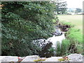
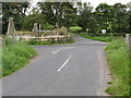
River Leitrim from Benraw Bridge
River Leitrim rises on the slopes of Slieve Croob.
Image: © Eric Jones
Taken: 23 Aug 2011
0.24 miles
4
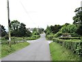
Herons Road at its junction with Kilnhill Road
Image: © Eric Jones
Taken: 7 Jun 2017
0.25 miles
5
Ruined cottage on Kilnhill Road
The cottage stands at the crossroads with Heron Road and Benraw Road.
Image: © Eric Jones
Taken: 23 Aug 2011
0.25 miles
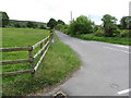
6
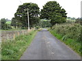
Herons Road approaching its junction with Kilnhill Road
Image: © Eric Jones
Taken: 23 Aug 2011
0.25 miles