IMAGES TAKEN NEAR TO
Close Road, CASTLEWELLAN, BT31 9RY
Introduction
This page details the photographs taken nearby to Close Road, BT31 9RY by members of the Geograph project.
The Geograph project started in 2005 with the aim of publishing, organising and preserving representative images for every square kilometre of Great Britain, Ireland and the Isle of Man.

There are currently over 7.5m images from over14,400 individuals and you can help contribute to the project by visiting https://www.geograph.org.uk
Image Map
Images are licensed for reuse under creativecommons.org/licenses/by-sa/2.0
Notes
- Clicking on the map will re-center to the selected point.
- The higher the marker number, the further away the image location is from the centre of the postcode.
Image Listing (11 Images Found)
Images are licensed for reuse under creativecommons.org/licenses/by-sa/2.0
Image
Details
Distance
1
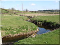
The meandering Muddocks River above Poags Bridge
Image: © Eric Jones
Taken: 26 Mar 2011
0.06 miles
2
The Close Road at Poags Bridge
The Poags Bridge spans the Muddocks River.
Image: © Eric Jones
Taken: 26 Mar 2011
0.08 miles
3
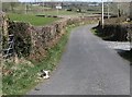
Wee lammie sunning itself on the side of the Close Road
This gives an idea of the paucity of traffic along this road. Mummy was sitting quite happily behind the gate.
Image: © Eric Jones
Taken: 26 Mar 2011
0.09 miles
4
The Muddock River above Poags Bridge
The Muddock is a tributary of the Bann, Northern Ireland's longest river.
Image: © Eric Jones
Taken: 26 Mar 2011
0.10 miles
5
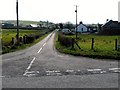
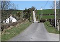
The northern end of Close Road
This view was taken from the junction with Lackan Road.
Image: © Eric Jones
Taken: 26 Mar 2011
0.11 miles
6
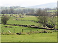
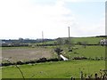
The flood plain of the Muddock River
The Muddock which rises in the Mournes is a tributary of the River Bann.
Image: © Eric Jones
Taken: 26 Mar 2011
0.14 miles
7
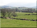
The Muddock Valley and the Mourne Mountains
The Muddock has its source in the Mournes.
Image: © Eric Jones
Taken: 26 Mar 2011
0.15 miles
8
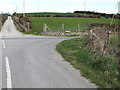
The intersection of Close Road and Lackan Road
These crossroads are located north of the Poage Bridge.
Image: © Eric Jones
Taken: 26 Mar 2011
0.16 miles
10
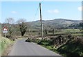
View east to a bend in the Lackan Road
Sections of this road which runs parallel with the Muddock River are liable to flooding. The hill is the background is Tullynasoo Mountain.
Image: © Eric Jones
Taken: 26 Mar 2011
0.24 miles