IMAGES TAKEN NEAR TO
Millvale Road, CASTLEWELLAN, BT31 9RD
Introduction
This page details the photographs taken nearby to Millvale Road, BT31 9RD by members of the Geograph project.
The Geograph project started in 2005 with the aim of publishing, organising and preserving representative images for every square kilometre of Great Britain, Ireland and the Isle of Man.

There are currently over 7.5m images from over14,400 individuals and you can help contribute to the project by visiting https://www.geograph.org.uk
Image Map
Images are licensed for reuse under creativecommons.org/licenses/by-sa/2.0
Notes
- Clicking on the map will re-center to the selected point.
- The higher the marker number, the further away the image location is from the centre of the postcode.
Image Listing (7 Images Found)
Images are licensed for reuse under creativecommons.org/licenses/by-sa/2.0
Image
Details
Distance
1
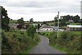
Farmhouse and buildings on Millvale Road, Moneyslane
Image: © Eric Jones
Taken: 15 Aug 2014
0.09 miles
2
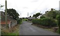
A collection of houses on a minor junction on Millvale Road
Image: © Eric Jones
Taken: 15 Aug 2014
0.13 miles
3
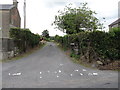
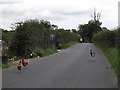
Minor road linking Millvale Road and Ballymackilreiny Road
This link road is also called Millvale Road.
Image: © Eric Jones
Taken: 15 Aug 2014
0.14 miles
4
Derryneill Baptist Church from the Ballymackilreiny Road
The marquee on the right houses the church's holiday mission. Ulster church folk have a particular liking for tented missions.
Image: © Eric Jones
Taken: 15 Aug 2014
0.14 miles
6
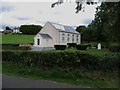
Derryneill Baptist Church
This is located on a backroad - Ballymackilreiny Road which links Ballyward and Lowtown. The church was built by a Baptist congregation in 1864 and is now
run on interdenominational lines as a centre for evangelistic preaching and teaching.
Image: © Eric Jones
Taken: 15 Aug 2014
0.15 miles
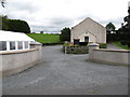
7
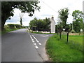
The Ballymackilreiny Road junction on the Millvale Road
Image: © Eric Jones
Taken: 15 Aug 2014
0.18 miles