IMAGES TAKEN NEAR TO
Rathfriland Road, CASTLEWELLAN, BT31 9RA
Introduction
This page details the photographs taken nearby to Rathfriland Road, BT31 9RA by members of the Geograph project.
The Geograph project started in 2005 with the aim of publishing, organising and preserving representative images for every square kilometre of Great Britain, Ireland and the Isle of Man.

There are currently over 7.5m images from over14,400 individuals and you can help contribute to the project by visiting https://www.geograph.org.uk
Image Map
Images are licensed for reuse under creativecommons.org/licenses/by-sa/2.0
Notes
- Clicking on the map will re-center to the selected point.
- The higher the marker number, the further away the image location is from the centre of the postcode.
Image Listing (5 Images Found)
Images are licensed for reuse under creativecommons.org/licenses/by-sa/2.0
Image
Details
Distance
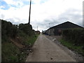
1
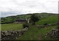
Approaching the farm house and outbuildings on the Moat Pad
The image was taken from the east. The telecommunications mast in the background is on Deehommed Mountain.
Image: © Eric Jones
Taken: 15 Aug 2014
0.01 miles
2
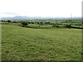
Grazing land below the Moat Pad
The Mournes form the background.
Image: © Eric Jones
Taken: 15 Aug 2014
0.07 miles
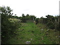
4
Approaching a farm building on the Moat Pad
Image: © Eric Jones
Taken: 15 Aug 2014
0.14 miles
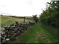
5
Farm buildings on the Moat Pad
Here, the Moat Pad follows the line of the farm access road.
Image: © Eric Jones
Taken: 15 Aug 2014
0.20 miles