IMAGES TAKEN NEAR TO
Castlewellan Road, CASTLEWELLAN, BT31 9JS
Introduction
This page details the photographs taken nearby to Castlewellan Road, BT31 9JS by members of the Geograph project.
The Geograph project started in 2005 with the aim of publishing, organising and preserving representative images for every square kilometre of Great Britain, Ireland and the Isle of Man.

There are currently over 7.5m images from over14,400 individuals and you can help contribute to the project by visiting https://www.geograph.org.uk
Image Map
Images are licensed for reuse under creativecommons.org/licenses/by-sa/2.0
Notes
- Clicking on the map will re-center to the selected point.
- The higher the marker number, the further away the image location is from the centre of the postcode.
Image Listing (28 Images Found)
Images are licensed for reuse under creativecommons.org/licenses/by-sa/2.0
Image
Details
Distance
1

Farm sheds on the A25 East of the Aghlisnafin turn-off
Image: © Eric Jones
Taken: 20 Sep 2021
0.01 miles
2
Farm buildings on the temporarily closed A25 at The Four Roads
Image: © Eric Jones
Taken: 10 Mar 2015
0.02 miles
3

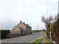
Modern farmhouse on the A25 close to the Aghlisnafin Road turn-off
Image: © Eric Jones
Taken: 20 Sep 2021
0.03 miles
4
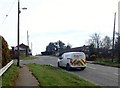
The Aghlisnafin Road junction on the A25 (Castlewellan Road)
Aghlisnafin Road is wide and straight road which is used by HGV serving the Walter Watson Steel Fabrication works.
Image: © Eric Jones
Taken: 19 Apr 2018
0.05 miles
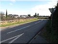
5

The Aghlisnafin Road turn-off viewed from the A25 (Castlewellan Road)
Image: © Eric Jones
Taken: 20 Sep 2021
0.05 miles
6
The mouth of the Aghlisnafin Road
Slieve Croob can be seen in the background.
Image: © Eric Jones
Taken: 20 Jul 2011
0.06 miles
7
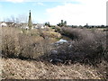
Flooded hollow below the A25 at the Four Roads
Image: © Eric Jones
Taken: 10 Mar 2015
0.06 miles
8

Road Closed - Unauthorised Entry is an Offence
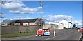
This is the A25 (Castlewellan to Clough road) at the Aughlisnafin Road junction. The road is closed between March 4 and March 13, 2015 to facilitate the resurfacing of 1.1km of the road. The blue sign bears the logo of the PSNI.
http://www.northernireland.gov.uk/news-drd-290115-kennedy-announces-205000
Image: © Eric Jones
Taken: 10 Mar 2015
0.07 miles
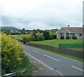
9
Farmhouse on the (A25) Ardnabannon Road
The image was taken from a point a few metres west of the Aghlisnafin Road junction. A minor road this side of the farmhouse runs south towards Maghera and Dundrum. Collectively, these junctions are referred to as the Magherasaul Crossroads.
Image: © Eric Jones
Taken: 19 Apr 2018
0.08 miles
10
The northern end of Kilmegan Road at the Four Roads
Image: © Eric Jones
Taken: 10 Mar 2015
0.08 miles