IMAGES TAKEN NEAR TO
Wood Grove, CASTLEWELLAN, BT31 9JD
Introduction
This page details the photographs taken nearby to Wood Grove, BT31 9JD by members of the Geograph project.
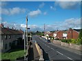
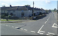
The Geograph project started in 2005 with the aim of publishing, organising and preserving representative images for every square kilometre of Great Britain, Ireland and the Isle of Man.

There are currently over 7.5m images from over14,400 individuals and you can help contribute to the project by visiting https://www.geograph.org.uk
Image Map
Images are licensed for reuse under creativecommons.org/licenses/by-sa/2.0
Notes
- Clicking on the map will re-center to the selected point.
- The higher the marker number, the further away the image location is from the centre of the postcode.
Image Listing (193 Images Found)
Images are licensed for reuse under creativecommons.org/licenses/by-sa/2.0
Image
Details
Distance
1
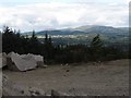
The sunlit town of Castlewellan viewed from Thomas's Mountain Quarry
The Slieve Croob range forms the background
Image: © Eric Jones
Taken: 23 Jul 2013
0.04 miles
2
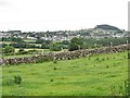
The market town of Castlewellan from the Burrenreagh Road
The forest topped hill on the right is Bunker Hill.
Image: © Eric Jones
Taken: 7 Jul 2016
0.05 miles
3
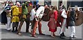
Re-enactment of a Viking attack at the Castlewellan Soma Festival
Image: © Eric Jones
Taken: 16 Jul 2016
0.09 miles
4
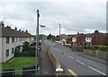
Burrenwood Road from the A50 Castlewellan Road
This is a residential road on the southern outskirts of the town.
Image: © Eric Jones
Taken: 20 Jul 2011
0.10 miles
5
Burrenwood Road, Castlewellan
This road runs westwards from its junction with Newcastle Road.
Image: © Eric Jones
Taken: 2 Aug 2013
0.10 miles
6
Burrenwood Road, Castlewellan
This runs westwards from its junction with Newcastle Road.
Image: © Eric Jones
Taken: 20 Sep 2021
0.11 miles

8
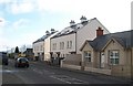
Town houses under construction in Newcastle Road, Castlewellan
This I remember as the site of the town's RUC barracks, a baricaded fortress in an overwhelmingly Nationalist town. The station saw more than its share of troubles. In 1972, an IRA bomber attempting to blow up the station was killed when the bomb went off prematurely and in 2000 an RUC officer was seriously injured by a booby-trap bomb left at the gate of the station. Yet, a few years later the authorities decided that Castlewellan, in common with many other small Ulster town, had no need of a police station and, in 2007, the site was sold at the height of the property boom for £400,000. Castlewellan is now policed from Newcastle.
Image: © Eric Jones
Taken: 8 Nov 2010
0.11 miles
9
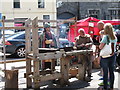
Viking craftsmen at the Soma Festival Castlewellan
Image: © Eric Jones
Taken: 16 Jul 2016
0.11 miles
10
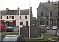
The rear of the IRA Memorial in the Lower Square, Castlewellan
Image: © Eric Jones
Taken: 14 Feb 2012
0.12 miles