IMAGES TAKEN NEAR TO
Burrenbridge Road, CASTLEWELLAN, BT31 9HT
Introduction
This page details the photographs taken nearby to Burrenbridge Road, BT31 9HT by members of the Geograph project.
The Geograph project started in 2005 with the aim of publishing, organising and preserving representative images for every square kilometre of Great Britain, Ireland and the Isle of Man.

There are currently over 7.5m images from over14,400 individuals and you can help contribute to the project by visiting https://www.geograph.org.uk
Image Map
Images are licensed for reuse under creativecommons.org/licenses/by-sa/2.0
Notes
- Clicking on the map will re-center to the selected point.
- The higher the marker number, the further away the image location is from the centre of the postcode.
Image Listing (14 Images Found)
Images are licensed for reuse under creativecommons.org/licenses/by-sa/2.0
Image
Details
Distance
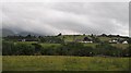
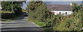
1
Houses on the Burrenbridge Road
The image was taken from the A50 (Newcastle Road)
Image: © Eric Jones
Taken: 1 Mar 2011
0.05 miles
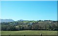
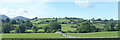
2
Houses on the Burrenridge Road
This view is taken across the incised Burren river from the A50 Newcastle Road.
Image: © Eric Jones
Taken: 17 Jul 2010
0.06 miles
3
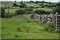
Drystone wall near Castlewellan
See Image In a different style from the previous one, this wall is in more fertile country, beside the Newcastle Road, near Castlewellan.
Image: © Albert Bridge
Taken: 16 Aug 2007
0.07 miles
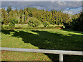
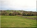
4
Settlement on the Burrenbridge Road
The image was taken across the Burren Valley from the Newcastle Road
Image: © Eric Jones
Taken: 20 Sep 2021
0.09 miles
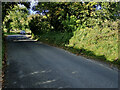
5
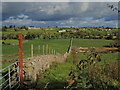
Farm boundatry dry stone wall running between Burrenbridge Road and the Burren River
Image: © Eric Jones
Taken: 22 Oct 2021
0.11 miles
7
Houses on the Burrenbridge Road
This view is taken from the A50.
Image: © Eric Jones
Taken: 8 Nov 2010
0.12 miles
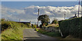
8
Cottage on the East side of Burrenbridge Road
Image: © Eric Jones
Taken: 22 Oct 2021
0.14 miles
9
Burrenbridge Road at the SE corner of Burrenwood
Image: © Eric Jones
Taken: 22 Oct 2021
0.17 miles