IMAGES TAKEN NEAR TO
Newcastle Road, CASTLEWELLAN, BT31 9HF
Introduction
This page details the photographs taken nearby to Newcastle Road, BT31 9HF by members of the Geograph project.
The Geograph project started in 2005 with the aim of publishing, organising and preserving representative images for every square kilometre of Great Britain, Ireland and the Isle of Man.

There are currently over 7.5m images from over14,400 individuals and you can help contribute to the project by visiting https://www.geograph.org.uk
Image Map
Images are licensed for reuse under creativecommons.org/licenses/by-sa/2.0
Notes
- Clicking on the map will re-center to the selected point.
- The higher the marker number, the further away the image location is from the centre of the postcode.
Image Listing (59 Images Found)
Images are licensed for reuse under creativecommons.org/licenses/by-sa/2.0
Image
Details
Distance
1
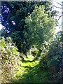
Approaching the SE end of the green lane
Image: © Eric Jones
Taken: 28 Sep 2022
0.05 miles
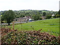
2
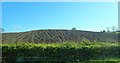
Ploughed drumlin on the east side of the A50 (Castlewellan Road)
Image: © Eric Jones
Taken: 12 May 2018
0.06 miles
3
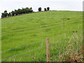
Drumlin on the North side of the Drumee path
Image: © Eric Jones
Taken: 15 Aug 2020
0.06 miles
4
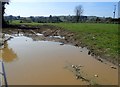
Flooded field gateway leading from the A50
Image: © Eric Jones
Taken: 6 Apr 2019
0.06 miles
5
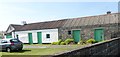
Traditional homestead buildings alongside the A50
Image: © Eric Jones
Taken: 6 Apr 2019
0.07 miles
6
Cottages on the A50 (Newcastle Road) at Drumee
These are set in a drumlin landscape.
Image: © Eric Jones
Taken: 15 Aug 2020
0.08 miles
7
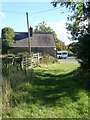
Green lane from Drumee Road reaching the A50 at Drumee Cemetery
This green lane is a section of the Newcastle Challenge Walk. Another section climbs E-W from the end of this path. The boarded-up house in the background was formerly that of the keeper of Drumee Cemetery.
Image: © Eric Jones
Taken: 28 Sep 2022
0.08 miles
8
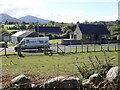
Houses on the A50 viewed from the Green Lane
Image: © Eric Jones
Taken: 28 Sep 2022
0.09 miles
9
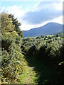
A view of Slieve Donard from the Drumee green lane
Image: © Eric Jones
Taken: 28 Sep 2022
0.09 miles
10
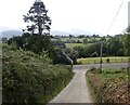
Descending towards the A50 at Drumee
The now derelict house at the junction was built as the cemetery keeper's residence.
Image: © Eric Jones
Taken: 15 Aug 2020
0.10 miles