IMAGES TAKEN NEAR TO
Ardnabannon Road, CASTLEWELLAN, BT31 9EN
Introduction
This page details the photographs taken nearby to Ardnabannon Road, BT31 9EN by members of the Geograph project.
The Geograph project started in 2005 with the aim of publishing, organising and preserving representative images for every square kilometre of Great Britain, Ireland and the Isle of Man.

There are currently over 7.5m images from over14,400 individuals and you can help contribute to the project by visiting https://www.geograph.org.uk
Image Map
Images are licensed for reuse under creativecommons.org/licenses/by-sa/2.0
Notes
- Clicking on the map will re-center to the selected point.
- The higher the marker number, the further away the image location is from the centre of the postcode.
Image Listing (13 Images Found)
Images are licensed for reuse under creativecommons.org/licenses/by-sa/2.0
Image
Details
Distance
1
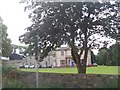
Ardnabannon Outdoor Pursuit Centre, Annsborough
This large house was built by the Murlands a family of mill owners. Annsborough at the time was an important linen weaving centre. The house, which overlooked the mills and the bleaching fields, is now an Outdoor Pursuits Centre
Image: © Eric Jones
Taken: 20 Aug 2009
0.01 miles
2
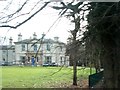
Ardnabannon Outdoor Education Centre, Annesborough
Image: © Eric Jones
Taken: 25 Feb 2011
0.02 miles
4
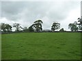
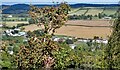
Farmland north of the A25 (Ardnabannon Road)
Image: © Eric Jones
Taken: 20 Jul 2011
0.12 miles
5
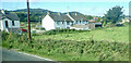
The rear of houses on the Ballylough Road at Annsborough
Image: © Eric Jones
Taken: 20 Sep 2021
0.16 miles
6
The southern end of Ballylough Road, Annsborough
Image: © Eric Jones
Taken: 2 Aug 2013
0.18 miles
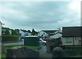
8
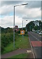
Houses on Ballylough Road viewed from the A25
Image: © Eric Jones
Taken: 20 Jul 2011
0.19 miles
9
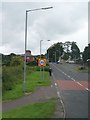
Linear settlement along the Ballylough Road, Annsborough
The house on the extreme right is at the junction with the A25. The image was taken from Bunkers Hill.
Image: © Eric Jones
Taken: 28 Sep 2022
0.21 miles
10
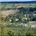
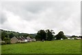
Part of the former mill village of Annsborough
Annsborough developed as a thriving linen mill village in the first decades of the 19thC. In common with the rest of the Ulster linen industry, it underwent a total decline in the mid 20th C. Ardbannon, the large mansion on the hill above was the home of the Murlands, a wealthy mill owning family. Built in 1868, it latterly was used as an outdoor centre by the LEA but was closed in 2017.
https://www.propertypal.com/former-ardnabannon-outdoor-education-centre-3-5-ardnabannon-road-castlewellan/764720
Image: © Eric Jones
Taken: 28 Sep 2022
0.22 miles