IMAGES TAKEN NEAR TO
Leitrim Road, CASTLEWELLAN, BT31 9BB
Introduction
This page details the photographs taken nearby to Leitrim Road, BT31 9BB by members of the Geograph project.
The Geograph project started in 2005 with the aim of publishing, organising and preserving representative images for every square kilometre of Great Britain, Ireland and the Isle of Man.

There are currently over 7.5m images from over14,400 individuals and you can help contribute to the project by visiting https://www.geograph.org.uk
Image Map
Images are licensed for reuse under creativecommons.org/licenses/by-sa/2.0
Notes
- Clicking on the map will re-center to the selected point.
- The higher the marker number, the further away the image location is from the centre of the postcode.
Image Listing (10 Images Found)
Images are licensed for reuse under creativecommons.org/licenses/by-sa/2.0
Image
Details
Distance
1
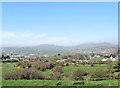
Rath west of Leitrim Road
Beyond the hawthorn fringed rath is the village of Leitrim backed by the Slieve Croob range.
Image: © Eric Jones
Taken: 8 Apr 2017
0.08 miles
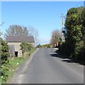
2
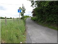
Cul de sac leading east from the Leitrim Road
The cul-de-sac, also known as Leitrim Road, comes to an end close to the boundary wall of the Castlewellan Castle Demesne.
Image: © Eric Jones
Taken: 7 Jun 2017
0.14 miles
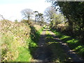
3
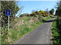
Lane leading up hill from Leitrim Road
This lane which reduces to a footpath at the Castlewellan Demesne boundary wall is also labelled on the map as Leitrim Road. This appears to be normal practise in Northern Ireland.
Image: © Eric Jones
Taken: 8 Apr 2017
0.16 miles
4
11kW powerlines crossing grazing land south of Bannanstown Road
Image: © Eric Jones
Taken: 7 Jun 2017
0.17 miles
5
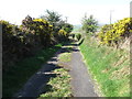
Lane descending towards the junction with Leitrim Road
Grass on the crown of the road suggest little usage.
Image: © Eric Jones
Taken: 8 Apr 2017
0.19 miles
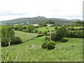
6
Tree-lined lane ascending towards the field barn
A forested hill in Castlewellan Demesne can be seen in the background. Grass on the crown of the road suggest little usage.
Image: © Eric Jones
Taken: 8 Apr 2017
0.22 miles
7
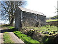
Field barn on lane leading from the Leitrim Road
Beyond the barn the lane is unpaved.
Image: © Eric Jones
Taken: 8 Apr 2017
0.22 miles
8
Field barn on minor lane leading to the Castlewellan Castle Demesne
Image: © Eric Jones
Taken: 8 Apr 2017
0.22 miles
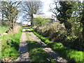
10
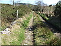
Lane above the field barn
Above the field barn the road is unpaved and its crown overgrown. Reeds are common in the crown vegetation and sections of the lane are flooded.
Image: © Eric Jones
Taken: 8 Apr 2017
0.24 miles