IMAGES TAKEN NEAR TO
Altnadua Road, CASTLEWELLAN, BT31 9AP
Introduction
This page details the photographs taken nearby to Altnadua Road, BT31 9AP by members of the Geograph project.
The Geograph project started in 2005 with the aim of publishing, organising and preserving representative images for every square kilometre of Great Britain, Ireland and the Isle of Man.

There are currently over 7.5m images from over14,400 individuals and you can help contribute to the project by visiting https://www.geograph.org.uk
Image Map
Images are licensed for reuse under creativecommons.org/licenses/by-sa/2.0
Notes
- Clicking on the map will re-center to the selected point.
- The higher the marker number, the further away the image location is from the centre of the postcode.
Image Listing (13 Images Found)
Images are licensed for reuse under creativecommons.org/licenses/by-sa/2.0
Image
Details
Distance
1
Farmstead on Altnadua Road
This image was taken from the Bann Road.
Image: © Eric Jones
Taken: 23 Aug 2011
0.06 miles
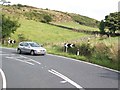
2
The Bann Road (A50) at the junction with a link road to the Altnadua Road just below the "Devil's Elbow"
Image: © Eric Jones
Taken: 15 Aug 2014
0.08 miles
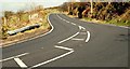
3
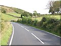
Easing into the "Devil's Elbow" on the A50
The "Devil's Elbow" marks the beginning of the climb to the top of the col between Slievebeg and Ballymagreehan.
Image: © Eric Jones
Taken: 15 Aug 2014
0.11 miles
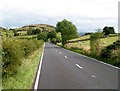
6
The Devil's Elbow near Castlewellan
See Image The view towards Castlewellan, along the Bann Road, at the Devil’s Elbow.
Image: © Albert Bridge
Taken: 25 Mar 2009
0.17 miles
7
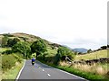
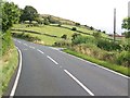
The Bann Road just west of the "Devil's Elbow"
Image: © Eric Jones
Taken: 15 Aug 2014
0.18 miles
8
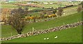
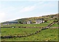
Drystones walls near Castlewellan
Drystone walls and whin bushes are common field boundaries in the countryside, north west of Castlewellan, near the Devil’s Elbow Image
Image: © Albert Bridge
Taken: 25 Mar 2009
0.20 miles
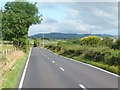
9
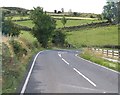
A straight section of the Bann Road north-west of the 'Devil's Elbow'
Image: © Eric Jones
Taken: 15 Aug 2014
0.21 miles
10
Approaching the Altnadua Cross Roads from the Castlewellan direction
Image: © Eric Jones
Taken: 15 Aug 2014
0.23 miles