IMAGES TAKEN NEAR TO
Bann Road, CASTLEWELLAN, BT31 9AE
Introduction
This page details the photographs taken nearby to Bann Road, BT31 9AE by members of the Geograph project.
The Geograph project started in 2005 with the aim of publishing, organising and preserving representative images for every square kilometre of Great Britain, Ireland and the Isle of Man.

There are currently over 7.5m images from over14,400 individuals and you can help contribute to the project by visiting https://www.geograph.org.uk
Image Map
Images are licensed for reuse under creativecommons.org/licenses/by-sa/2.0
Notes
- Clicking on the map will re-center to the selected point.
- The higher the marker number, the further away the image location is from the centre of the postcode.
Image Listing (6 Images Found)
Images are licensed for reuse under creativecommons.org/licenses/by-sa/2.0
Image
Details
Distance
1
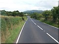
An undulating section of the Bann Road (A50) east of Ballyward
Image: © Eric Jones
Taken: 15 Aug 2014
0.05 miles
2
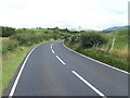
The A50 heading north-westwards towards Ballyward
Image: © Eric Jones
Taken: 15 Aug 2014
0.06 miles
4
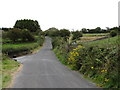
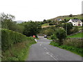
The Magheramayo Road south of the Dolly's Brae Crossroads
This road leads on beyond the crossroads towards the village of Leitrim.
Image: © Eric Jones
Taken: 1 Sep 2011
0.22 miles
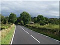
5
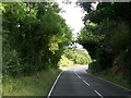
A leafy arch over the Bann Road (A50) near the Magheramayo Road junction
Image: © Eric Jones
Taken: 15 Aug 2014
0.23 miles
6
The Tullynasoo Road at its junction with the A50 (Bann Road) at Magheramayo
The A50 is a busy artery linking the South Down coast lands with A1 corridor at Banbridge.
Image: © Eric Jones
Taken: 1 Sep 2011
0.24 miles