IMAGES TAKEN NEAR TO
Strangford Avenue, DOWNPATRICK, BT30 9UJ
Introduction
This page details the photographs taken nearby to Strangford Avenue, BT30 9UJ by members of the Geograph project.
The Geograph project started in 2005 with the aim of publishing, organising and preserving representative images for every square kilometre of Great Britain, Ireland and the Isle of Man.

There are currently over 7.5m images from over14,400 individuals and you can help contribute to the project by visiting https://www.geograph.org.uk
Image Map
Images are licensed for reuse under creativecommons.org/licenses/by-sa/2.0
Notes
- Clicking on the map will re-center to the selected point.
- The higher the marker number, the further away the image location is from the centre of the postcode.
Image Listing (12 Images Found)
Images are licensed for reuse under creativecommons.org/licenses/by-sa/2.0
Image
Details
Distance
1
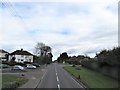
Entering Killyleagh from the south-west along Downpatrick Road
The two road junctions are those with Grove Park (on the left) and Inishmore (on the right)
Image: © Eric Jones
Taken: 17 Apr 2017
0.13 miles
2
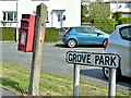
Postbox BT30 753, Killyleagh (May 2017)
Post-mounted EIIR postbox (BT30 753) at Grove Park/Downpatrick Road.
Image: © Albert Bridge
Taken: 1 May 2017
0.19 miles
3
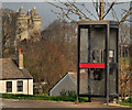
Telephone box, Killyleagh
A telephone box at Kerry Wind off the Downpatrick Road. Killyleagh Castle Image and Image is in the background. The photograph also shows, by accident, that the centre of Killyleagh is in a dip (the valley of the Dibney River).
Image: © Albert Bridge
Taken: 22 Mar 2012
0.22 miles
4
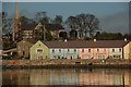
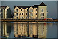
Killyleagh harbour (1)
Killyleagh’s fortunes were closely linked with linen and leather. Both have now gone. The small harbour was used by a local merchant to import coal. That, too, is history with the last ship calling in 1991. The harbour has been redeveloped for housing. This view could be any one of many similar developments anywhere save for the parish church of St John the Evangelist in the background. It was consecrated in 1640. The spire was added in 1825. The churchyard contains the grave of the Hon Henry Blackwood, the captain of HMS Euryalus at the Battle of Trafalgar.
Image: © Albert Bridge
Taken: 20 Dec 2006
0.22 miles
5
Killyleagh harbour (2)
See also Image This is the view of the more anonymous seaward end of the former harbour.
Image: © Albert Bridge
Taken: 20 Dec 2006
0.22 miles
6
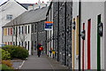
Plantation Street, Killyleagh
Plantation Street is just off the Downpatrick Road, in the centre of Killyleagh. The houses on this side are recent additions built to match the older houses on the other side.
Image: © Albert Bridge
Taken: 18 Apr 2007
0.22 miles
7
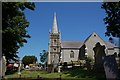
The parish church, Killyleagh
The (CoI) parish church of St John the Evangelist stands in a prominent position on the Church Hill overlooking part of the town and Strangford Lough. The church dates from about 1650. It was renovated in 1859 and had further improvements in 1862.
Image: © Albert Bridge
Taken: 7 Jun 2007
0.22 miles
8
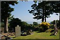
Graveyard, Killyleagh parish church
See Image This is the church cemetery with Strangford Lough visible in the background.
Image: © Albert Bridge
Taken: 7 Jun 2007
0.22 miles
9
Seaside bungalows at Cuan Beach, Killyleagh
The garden of the bungalow nearest the camera is a delight. Cuan, meaning calm or peaceful, is the Irish name for Strangford Lough.
Image: © Eric Jones
Taken: 13 Oct 2012
0.24 miles
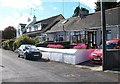
10

Service Station on the Downpatrick Road
Image: © Mick Garratt
Taken: 4 Aug 2016
0.24 miles