IMAGES TAKEN NEAR TO
Island Road, DOWNPATRICK, BT30 9UB
Introduction
This page details the photographs taken nearby to Island Road, BT30 9UB by members of the Geograph project.
The Geograph project started in 2005 with the aim of publishing, organising and preserving representative images for every square kilometre of Great Britain, Ireland and the Isle of Man.

There are currently over 7.5m images from over14,400 individuals and you can help contribute to the project by visiting https://www.geograph.org.uk
Image Map
Images are licensed for reuse under creativecommons.org/licenses/by-sa/2.0
Notes
- Clicking on the map will re-center to the selected point.
- The higher the marker number, the further away the image location is from the centre of the postcode.
Image Listing (7 Images Found)
Images are licensed for reuse under creativecommons.org/licenses/by-sa/2.0
Image
Details
Distance
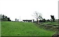
2
Private farm lane ascending a drumlin slope east of the A22
Image: © Eric Jones
Taken: 22 Apr 2017
0.14 miles
3
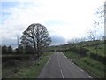
Leading into a sharp left hand bend on the A22 south-west of Killyleagh
Image: © Eric Jones
Taken: 17 Apr 2017
0.17 miles
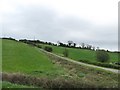
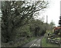
4
Farm lane leading from the Killyleagh Road
Image: © Eric Jones
Taken: 13 Oct 2012
0.18 miles
5
Junction with private farm lane on the A22 south of Killyleagh
Image: © Eric Jones
Taken: 17 Apr 2017
0.19 miles
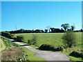
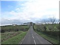
6
Island Road from its junction with the A22 (Killyleagh Road)
This road leads to the quay opposite Gibbs Island.
Image: © Eric Jones
Taken: 17 Apr 2017
0.19 miles
7
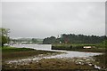
Mullagh Quay, Strangford Lough
The quay is used during the summer months when boat trips arrive from Strangford and Portaferry. At other times leisure and fishing craft use the quay, which is accessible at most states of the tide.
Image: © Bob Jones
Taken: 25 May 2005
0.21 miles