IMAGES TAKEN NEAR TO
Ardigon Road, DOWNPATRICK, BT30 9TB
Introduction
This page details the photographs taken nearby to Ardigon Road, BT30 9TB by members of the Geograph project.
The Geograph project started in 2005 with the aim of publishing, organising and preserving representative images for every square kilometre of Great Britain, Ireland and the Isle of Man.

There are currently over 7.5m images from over14,400 individuals and you can help contribute to the project by visiting https://www.geograph.org.uk
Image Map
Images are licensed for reuse under creativecommons.org/licenses/by-sa/2.0
Notes
- Clicking on the map will re-center to the selected point.
- The higher the marker number, the further away the image location is from the centre of the postcode.
Image Listing (4 Images Found)
Images are licensed for reuse under creativecommons.org/licenses/by-sa/2.0
Image
Details
Distance
1
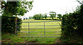
Gate near Crossgar
A gate, on the Ardigon Road Image, leading to a field on the side of a low drumlin.
Image: © Albert Bridge
Taken: 6 Jul 2010
0.18 miles
2
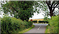
The Ardigon Road near Crossgar
See Image The same road, in this square, as it approaches the Ballytrim Road from Crossgar to Killyleagh.
Image: © Albert Bridge
Taken: 6 Jul 2010
0.20 miles

4
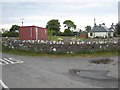
Bungalow and container at Ardigon crossroads
An old container presumably makes a useful garden shed.
Image: © Oliver Dixon
Taken: 11 May 2007
0.24 miles