IMAGES TAKEN NEAR TO
Woodland Crescent, DOWNPATRICK, BT30 9SN
Introduction
This page details the photographs taken nearby to Woodland Crescent, BT30 9SN by members of the Geograph project.
The Geograph project started in 2005 with the aim of publishing, organising and preserving representative images for every square kilometre of Great Britain, Ireland and the Isle of Man.

There are currently over 7.5m images from over14,400 individuals and you can help contribute to the project by visiting https://www.geograph.org.uk
Image Map
Images are licensed for reuse under creativecommons.org/licenses/by-sa/2.0
Notes
- Clicking on the map will re-center to the selected point.
- The higher the marker number, the further away the image location is from the centre of the postcode.
Image Listing (9 Images Found)
Images are licensed for reuse under creativecommons.org/licenses/by-sa/2.0
Image
Details
Distance
1
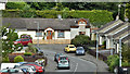
Osborne Drive, Shrigley (July 2017)
Social housing off the Crossgar Road.
Image: © Albert Bridge
Taken: 29 Jul 2017
0.12 miles
2
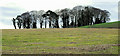
Rath, Shrigley
A rath, above Shrigley, between the Clea Lough Road and the Crossgar Road.
Image: © Albert Bridge
Taken: 24 Jan 2011
0.15 miles
3
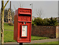
Letter box, Shrigley
Post-mounted EIIR letter box (BT30 281) at Osborne Drive (River Row before the village was rebuilt in the late 60’s). The Shrigley Memorial Image is in the background).
Image: © Albert Bridge
Taken: 22 Mar 2012
0.16 miles
4
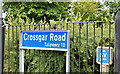
Blue road name sign, Shrigley (July 2017)
Road name sign, with white letters on a reflective blue background, at the Shrigley Road end of the Crossgar Road.
Image: © Albert Bridge
Taken: 29 Jul 2017
0.19 miles
5
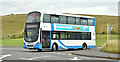
Bus, Shrigley (July 2017)
An Ulsterbus Wright-bodied Volvo (2236 – OEZ 7236) leaving the turning circle, at the Shrigley Memorial Image, with the 10.50 to Downpatrick. The stop is on the main road. The circle is used for rest and turning.
Image: © Albert Bridge
Taken: 29 Jul 2017
0.19 miles
6
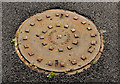
Portadown Foundry manhole cover, Shrigley
Image: © Albert Bridge
Taken: 22 Mar 2012
0.20 miles
7
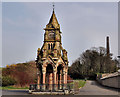
The Shrigley Memorial (2012)
See Image (February 2008). More than four years later the memorial remains untouched and still “at risk”.
Image: © Albert Bridge
Taken: 22 Mar 2012
0.22 miles
8
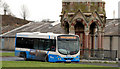
Bus, Shrigley
A Wrightbus Solar-bodied Scania about to depart from the Shrigley memorial Image with the 11.10 service to Belfast (Laganside Buscentre) – service no 511. The “5” prefix indicates an Ulsterbus service picking up within the city boundary on inward journeys (and setting down on outward ones) – formerly a prerogative of Citybus (now Metro).
Image: © Albert Bridge
Taken: 24 Jan 2011
0.24 miles
9
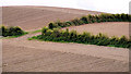
Drumlin near Killyleagh
Three ploughed fields on the side of a drumlin, to the north west of Killyleagh.
Image: © Albert Bridge
Taken: 17 May 2010
0.25 miles