IMAGES TAKEN NEAR TO
Well Lane, DOWNPATRICK, BT30 9RY
Introduction
This page details the photographs taken nearby to Well Lane, BT30 9RY by members of the Geograph project.
The Geograph project started in 2005 with the aim of publishing, organising and preserving representative images for every square kilometre of Great Britain, Ireland and the Isle of Man.

There are currently over 7.5m images from over14,400 individuals and you can help contribute to the project by visiting https://www.geograph.org.uk
Image Map
Images are licensed for reuse under creativecommons.org/licenses/by-sa/2.0
Notes
- Clicking on the map will re-center to the selected point.
- The higher the marker number, the further away the image location is from the centre of the postcode.
Image Listing (138 Images Found)
Images are licensed for reuse under creativecommons.org/licenses/by-sa/2.0
Image
Details
Distance
1
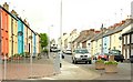
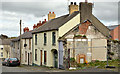
Shore Street, Killyleagh
The area between Catherine Street and the harbour was redeveloped by the Housing Executive, about 20 or so years ago, with houses in the traditional style. This is Shore Street, looking towards Catherine Street and Cross Street. The houses on the left are the “new” ones while those on the right are a bit older.
Image: © Albert Bridge
Taken: 18 May 2009
0.02 miles
2
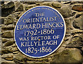
Edward Hincks plaque, Killyleagh
A plaque, just outside the church grounds, commemorating the Rev Edward Hincks http://en.wikipedia.org/wiki/Edward_Hincks a former rector. Erected by the old East Down Rural District Council and one of the few surviving objects still bearing its name.
Image: © Albert Bridge
Taken: 22 Mar 2012
0.03 miles
3
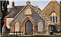
Mausoleum, Killyleagh (1)
A mausoleum, in the graveyard at the Church of St John the Evangelist, containing the remains of members of the Heron family. See also Image
Image: © Albert Bridge
Taken: 22 Mar 2012
0.04 miles
4
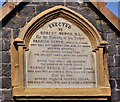
Mausoleum, Killyleagh (2)
See Image A plaque giving the names of those interred within.
Image: © Albert Bridge
Taken: 22 Mar 2012
0.04 miles
5
Nos 4-10 Church Hill, Killyleagh (2013-1)
Boarded-up houses, at the Cross Street (background) end of Church Hill, offered for sale. This photograph appears as a matter of record only. I have no connection with any of the parties involved in the sale. Image shows the view in the other direction.
Image: © Albert Bridge
Taken: 1 May 2013
0.04 miles
6
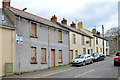
Nos 4-10 Church Hill, Killyleagh (2013-2)
See Image The view in the other direction.
Image: © Albert Bridge
Taken: 1 May 2013
0.04 miles
7
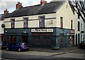
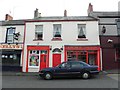
The Central Bar, Killyleagh
Public house located at the crossroads in the centre of Killyleagh, specifically at the corner of Cross Street and Shore Street. Situated at the corner you can see a large grey stone (granite, I think). I am unsure of the purpose of the stone, possibly it was placed there as a seat or to protect the corner of the building from passing coaches. Notably, the stone has a rivet bench mark inserted into it - see Image
Image: © Rossographer
Taken: 27 Mar 2010
0.04 miles
8
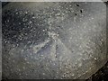
Bench Mark, Killyleagh
Rivet bench mark located on the large stone at the corner of the Central Bar in Killyleagh - see Image Notably his mark does not appear on either the 1970s or 2007 OSNI maps; it does appear on historic maps going back as far as 1859 so appears to date from the first levelling of Ireland in the 1840s. The mark was levelled to a height of 50.4 feet above sea level.
See also http://www.geograph.org.uk/search.php?i=11037856 for many other examples I have found.
Image: © Rossographer
Taken: 27 Mar 2010
0.04 miles
9
Kelleys / Neales Caf? / A Murray, Butcher
They are located at Comber Road, Killyleagh
Image: © Kenneth Allen
Taken: 8 Oct 2011
0.04 miles
10
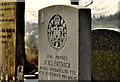
Headstone, Killyleagh (2)
A headstone marking the grave of Pte J Kilpatrick of the Royal Inniskilling Fusiliers who died in 1919.
Image: © Albert Bridge
Taken: 22 Mar 2012
0.04 miles