IMAGES TAKEN NEAR TO
Sloane Crescent, DOWNPATRICK, BT30 9RB
Introduction
This page details the photographs taken nearby to Sloane Crescent, BT30 9RB by members of the Geograph project.
The Geograph project started in 2005 with the aim of publishing, organising and preserving representative images for every square kilometre of Great Britain, Ireland and the Isle of Man.

There are currently over 7.5m images from over14,400 individuals and you can help contribute to the project by visiting https://www.geograph.org.uk
Image Map
Images are licensed for reuse under creativecommons.org/licenses/by-sa/2.0
Notes
- Clicking on the map will re-center to the selected point.
- The higher the marker number, the further away the image location is from the centre of the postcode.
Image Listing (48 Images Found)
Images are licensed for reuse under creativecommons.org/licenses/by-sa/2.0
Image
Details
Distance
1
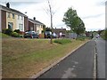
New houses on the north-eastern outskirts of Killyleagh
Image: © Eric Jones
Taken: 17 Apr 2017
0.01 miles
2
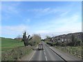
Comber Road, Killyleagh
The main A22 road out of Killyleagh to the north.
Image: © Oliver Dixon
Taken: 11 May 2007
0.02 miles
3
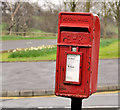
Letter box, Killyleagh
Post-mounted EIIR letter box (BT30 797) at Hillfoot Gardens (though possibly officially described as “Sloan Crescent”).
Image: © Albert Bridge
Taken: 12 Mar 2012
0.04 miles
4
New houses above the Comber Road, Killyleagh
This new estate overlooks the football ground.
Image: © Eric Jones
Taken: 17 Apr 2017
0.05 miles
5
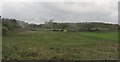
Waste ground on the edge of Killyleagh village
This land is at the southern edge of the sports ground.
Image: © Eric Jones
Taken: 22 Apr 2017
0.06 miles
6
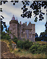
Killyleagh Castle
Killyleagh Castle was described by Harold Nicolson over a century ago as "...pricking castellated ears above the smoke of its own village and towering like some chateau of the Loire above the tides of Strangford Lough." This is the back door!
http://www.panoramio.com/user/574636
Image: © Shane Killen
Taken: 24 Oct 2007
0.10 miles
7
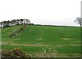
Drumlin slope farmland north of Killyleagh
This is located on the east side of the A22.
Image: © Eric Jones
Taken: 22 Apr 2017
0.11 miles
8
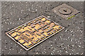
NICL fire hydrant cover, Killyleagh
See Image Another NICL fire hydrant cover. This one is in the Castleview estate and is very lightly worn. The adjacent stop-valve cover does not display a maker’s name.
Image: © Albert Bridge
Taken: 1 May 2013
0.11 miles
9

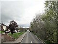
Entering the Killyleagh 30mph zone from the north along the A22
Image: © Eric Jones
Taken: 17 Apr 2017
0.11 miles
10
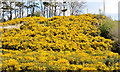
Whin bushes, Killyleagh
A display of whins on the north eastern side of the Comber Road – probably the best I’ve seen in 2013.
Image: © Albert Bridge
Taken: 1 May 2013
0.11 miles