IMAGES TAKEN NEAR TO
Comber Road, DOWNPATRICK, BT30 9PG
Introduction
This page details the photographs taken nearby to Comber Road, BT30 9PG by members of the Geograph project.
The Geograph project started in 2005 with the aim of publishing, organising and preserving representative images for every square kilometre of Great Britain, Ireland and the Isle of Man.

There are currently over 7.5m images from over14,400 individuals and you can help contribute to the project by visiting https://www.geograph.org.uk
Image Map
Images are licensed for reuse under creativecommons.org/licenses/by-sa/2.0
Notes
- Clicking on the map will re-center to the selected point.
- The higher the marker number, the further away the image location is from the centre of the postcode.
Image Listing (8 Images Found)
Images are licensed for reuse under creativecommons.org/licenses/by-sa/2.0
Image
Details
Distance
1
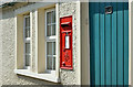
GVIR wall box BT30 612, Toy and Kirkland, Killyleagh/Killinchy (May 2017)
GVIR wall box (BT30 612) at the former Toye post office on the Comber Road. Note – the former post office and the townland use different spellings.
Image: © Albert Bridge
Taken: 1 May 2017
0.03 miles
2
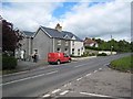
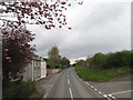
The postman delivers
Rathcunningham on the A22.
Image: © Oliver Dixon
Taken: 11 May 2007
0.05 miles
3
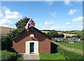
Toye Orange Hall
This is the home of LOL 1077 and the base of the Toye Flute Band.
https://www.bing.com/videos/search?q=toye+flute+band%23&view=detail&mid=A6C2B3614C8F85E4ED83A6C2B3614C8F85E4ED83&FORM=VIRE
Image: © Eric Jones
Taken: 30 Aug 2017
0.06 miles
4
Toye Orange Hall
This is the home of LOL 1077 and the base of the Toye Flute Band.
https://www.bing.com/videos/search?q=toye+flute+band%23&view=detail&mid=A6C2B3614C8F85E4ED83A6C2B3614C8F85E4ED83&FORM=VIRE
Image: © Eric Jones
Taken: 22 Apr 2017
0.06 miles
5
The Rathcunningham Road junction on the A22
This is located in the Townland of Toye.
Image: © Eric Jones
Taken: 17 Apr 2017
0.07 miles
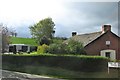
6
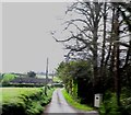
Kirkland Road, Toy and Kirkland TD
This road links with the Lower Clay Road.
Image: © Eric Jones
Taken: 22 Apr 2017
0.13 miles
7
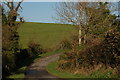
The Clay Road near Killyleagh
The Clay Road runs from near Killinchy, towards the Clay Lakes near Killyleagh. Drumlins predominate in the area but there are lower, marshy areas near the lakes. The view is in the general direction of Killinchy.
Image: © Albert Bridge
Taken: 20 Nov 2006
0.23 miles
8
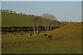
Drumlin country (9)
This is the drumlin country north of Killyleagh showing the “basket of eggs” landscape. The Comber-Downpatrick road (running from right to left) is marked by the hedge line in the middle of the photo. This view is typical of the area.
Image: © Albert Bridge
Taken: 20 Dec 2006
0.23 miles