IMAGES TAKEN NEAR TO
The Old Mill, DOWNPATRICK, BT30 9GY
Introduction
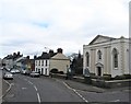
This page details the photographs taken nearby to The Old Mill, BT30 9GY by members of the Geograph project.
The Geograph project started in 2005 with the aim of publishing, organising and preserving representative images for every square kilometre of Great Britain, Ireland and the Isle of Man.

There are currently over 7.5m images from over14,400 individuals and you can help contribute to the project by visiting https://www.geograph.org.uk
Image Map
Images are licensed for reuse under creativecommons.org/licenses/by-sa/2.0
Notes
- Clicking on the map will re-center to the selected point.
- The higher the marker number, the further away the image location is from the centre of the postcode.
Image Listing (123 Images Found)
Images are licensed for reuse under creativecommons.org/licenses/by-sa/2.0
Image
Details
Distance
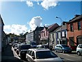
1
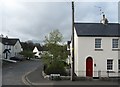
Houses on The Old Mill Estate in Killyleagh
Image: © Eric Jones
Taken: 22 Apr 2017
0.03 miles
2
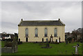
1st Presbyterian Church, Killyleagh, County Down, Northern Ireland
Presbyterian Church in Killyleagh, County Down
Image: © Alf Beard
Taken: 29 Dec 2019
0.05 miles
3
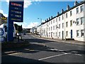
View west along the eastern end of Downpatrick Street
Image: © Eric Jones
Taken: 13 Oct 2012
0.05 miles
4
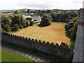
Killyleagh First Presbyterian Church from castle
View from castle tower. The church is just beyond the field in the photo.
Image: © David Hawgood
Taken: 4 Sep 2009
0.05 miles
6
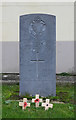
William Montgomery
War grave in 1st Presbyterian Churchyard, Killyleagh, County Down, N.I.
Image: © Alf Beard
Taken: 29 Dec 2019
0.06 miles
7
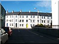
Terraced houses in the centre of Killyleagh
This image was taken from Irish Street.
Image: © Eric Jones
Taken: 13 Oct 2012
0.07 miles
8
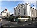
Killyleagh Presbyterian Church
It is located at the corner of Downpatrick Road and Irish Street
Image: © Kenneth Allen
Taken: 8 Oct 2011
0.09 miles
9
Second Killyleagh Presbyterian Church
This is located in Downpatrick Road.
Image: © Eric Jones
Taken: 17 Apr 2017
0.09 miles
10
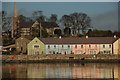
Killyleagh harbour (1)
Killyleagh’s fortunes were closely linked with linen and leather. Both have now gone. The small harbour was used by a local merchant to import coal. That, too, is history with the last ship calling in 1991. The harbour has been redeveloped for housing. This view could be any one of many similar developments anywhere save for the parish church of St John the Evangelist in the background. It was consecrated in 1640. The spire was added in 1825. The churchyard contains the grave of the Hon Henry Blackwood, the captain of HMS Euryalus at the Battle of Trafalgar.
Image: © Albert Bridge
Taken: 20 Dec 2006
0.10 miles