IMAGES TAKEN NEAR TO
The Meadows, DOWNPATRICK, BT30 9GT
Introduction
This page details the photographs taken nearby to The Meadows, BT30 9GT by members of the Geograph project.
The Geograph project started in 2005 with the aim of publishing, organising and preserving representative images for every square kilometre of Great Britain, Ireland and the Isle of Man.

There are currently over 7.5m images from over14,400 individuals and you can help contribute to the project by visiting https://www.geograph.org.uk
Image Map
Images are licensed for reuse under creativecommons.org/licenses/by-sa/2.0
Notes
- Clicking on the map will re-center to the selected point.
- The higher the marker number, the further away the image location is from the centre of the postcode.
Image Listing (4 Images Found)
Images are licensed for reuse under creativecommons.org/licenses/by-sa/2.0
Image
Details
Distance
1
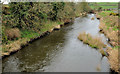
The Ballynahinch River, Kilmore near Crossgar
See Image The view, downstream, of the Ballynahinch River from the other side of the Kilmore Bridge Image
Image: © Albert Bridge
Taken: 27 Feb 2012
0.07 miles
2
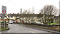
The Kilmore Bridge near Crossgar
The Kilmore Bridge, subject to a weight limit of ten tonnes, carries the minor Kilmore Road across the Ballynahinch River. Part of Kilmore village is in the background. Last seen in February 2006 Image
Image: © Albert Bridge
Taken: 27 Feb 2012
0.08 miles
3
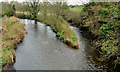
Two rivers, Kilmore near Crossgar
The confluence of the Ballynahinch River Image (left) and the Glasswater River, looking upstream from the Kilmore Bridge Image Image shows the view from the other side of the bridge.
Image: © Albert Bridge
Taken: 27 Feb 2012
0.09 miles
4
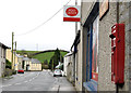
Letter box, Kilmore near Crossgar
Wall-mounted EIIR letter box (BT30 655) at Kilmore post office. The official address is 16-18 Kilmore Village although the street is the Kilmore Road.
Image: © Albert Bridge
Taken: 27 Feb 2012
0.10 miles