IMAGES TAKEN NEAR TO
Downpatrick Road, DOWNPATRICK, BT30 9EQ
Introduction
This page details the photographs taken nearby to Downpatrick Road, BT30 9EQ by members of the Geograph project.
The Geograph project started in 2005 with the aim of publishing, organising and preserving representative images for every square kilometre of Great Britain, Ireland and the Isle of Man.

There are currently over 7.5m images from over14,400 individuals and you can help contribute to the project by visiting https://www.geograph.org.uk
Image Map
Images are licensed for reuse under creativecommons.org/licenses/by-sa/2.0
Notes
- Clicking on the map will re-center to the selected point.
- The higher the marker number, the further away the image location is from the centre of the postcode.
Image Listing (12 Images Found)
Images are licensed for reuse under creativecommons.org/licenses/by-sa/2.0
Image
Details
Distance
1
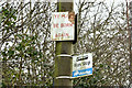
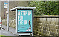
Biblical message and bus stop, Crossgar (February 2016)
A biblical message and bus stop sign, attached to a telegraph pole, opposite Ruthven Rise on the Downpatrick Road.
Image: © Albert Bridge
Taken: 17 Feb 2016
0.02 miles
3
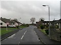
Rocksfield Estate, Crossgar
This is one of a number of modern estates on the southern outskirts of Crossgar,
Image: © Eric Jones
Taken: 25 Nov 2015
0.06 miles
5
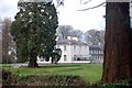
Tobermore Monastery
Known as Crossgar House until 1950 when it was bought by The Passionist Community who have used it for various purposes including, a school, a seminary, and currently a retreat house.
Image: © Paul McIlroy
Taken: 9 Mar 2008
0.07 miles
6
New housing site, Crossgar - February 2016(2)
See Image Another part of the same site. This photograph appears as a matter of record only. I have no connection with the agent or builder and cannot enter into correspondence.
Image: © Albert Bridge
Taken: 17 Feb 2016
0.11 miles
7
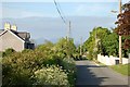
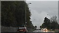
Crossgar
Drake's bridge road, the Mourne mountains can be seen in the distance.
Image: © Paul McIlroy
Taken: 22 May 2007
0.11 miles
8
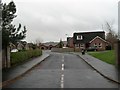
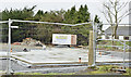
New housing site, Crossgar - February 2016(1)
Part of a site for three new houses on the Drake’s Bridge Road. Described by the agent as “A select development of only 3 homes located just a short distance to the heart of this historic Village of Crossgar. Located between Saintfield and Downpatrick, Crossgar is only 15 miles from Belfast and offers a range of local shops and service. Opportunities to buy such homes in a central location within close proximity to the Village whilst boasting a small cul de sac of properties do not come along often and as such we would encourage to register early interest. The development itself comprises exclusively of only 3 detached homes which can be tailored to any discerning purchasers requirements.” This photograph appears as a matter of record only. I have no connection with the agent or builder and cannot enter into correspondence. See also Image
Image: © Albert Bridge
Taken: 17 Feb 2016
0.12 miles
9
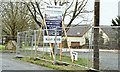
National living wage poster, Crossgar (February 2016)
A poster at the Westlands/Tobar Mhuire bus stop on the Downpatrick Road – part of an official information campaign before the introduction of the national living wage https://en.wikipedia.org/wiki/Living_wage_in_the_United_Kingdom in April 2016.
Image: © Albert Bridge
Taken: 17 Feb 2016
0.16 miles
10
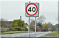
40 mph speed limit sign, Crossgar (February 2016)
The sign at the start of the 40 mph zone on the Downpatrick Road (inward).
Image: © Albert Bridge
Taken: 17 Feb 2016
0.17 miles