IMAGES TAKEN NEAR TO
William Street, DOWNPATRICK, BT30 9EF
Introduction
This page details the photographs taken nearby to William Street, BT30 9EF by members of the Geograph project.
The Geograph project started in 2005 with the aim of publishing, organising and preserving representative images for every square kilometre of Great Britain, Ireland and the Isle of Man.

There are currently over 7.5m images from over14,400 individuals and you can help contribute to the project by visiting https://www.geograph.org.uk
Image Map
Images are licensed for reuse under creativecommons.org/licenses/by-sa/2.0
Notes
- Clicking on the map will re-center to the selected point.
- The higher the marker number, the further away the image location is from the centre of the postcode.
Image Listing (63 Images Found)
Images are licensed for reuse under creativecommons.org/licenses/by-sa/2.0
Image
Details
Distance
1
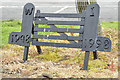
Women's Institute "gate", Crossgar
See Image A miniature gate, at The Square, marking 50 years of Crossgar Women’s Institute (1948-98).
Image: © Albert Bridge
Taken: 13 Jun 2013
0.04 miles
2
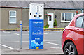
E-car charge point, Crossgar
An e-car charge point at the car park, The Square.
Image: © Albert Bridge
Taken: 13 Jun 2013
0.04 miles
3
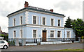
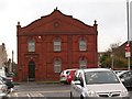
Former Northern Bank, Crossgar
Not quite as old as it appears, the former Northern Bank, overlooking The Square at William Street, is thought to have been built circa 1924-25. The low extension (right) is reported to date from 1980. The branch closed in 2011.
Image: © Albert Bridge
Taken: 13 Jun 2013
0.05 miles
4
Sir James Martin plaque, Crossgar
A plaque at The Square commemorating locally-born Sir James Martin inventor of the aircraft ejector seat http://www.ejectorseats.co.uk/milestones_in_ejection_seat_hist.htm and joint founder of the Martin Maker Aircraft Corporation http://www.martin-baker.com/about/history-and-developments. The reflection is the former Northern Bank Image
Image: © Albert Bridge
Taken: 13 Jun 2013
0.05 miles
5
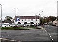
The Masonic Hall, Market Square, Crossgar
Image: © Eric Jones
Taken: 25 Nov 2015
0.06 miles
6
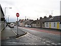
View west along Killyleagh Road
The image was taken from the corner of James Street.
Image: © Eric Jones
Taken: 25 Nov 2015
0.06 miles
7
The Old Market House, Crossgar
The Market House was built in 1829 and housed a weekly market until the last decade of the 19thC. In 1900 the upper floor was converted to a school. Later the building served as a church hall. Recently, following a period of dereliction, the Market House has been restored as a Pre-school nursery for the Friends Day Nursery.
Image: © Eric Jones
Taken: 25 Nov 2015
0.07 miles
8
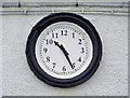
The Market House clock, Crossgar
An accurate clock, on the listed market house of 1829, at The Square.
Image: © Albert Bridge
Taken: 13 Jun 2013
0.07 miles
9
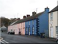
Terraced housing in Jon Street and Market Street, Crossgar
Image: © Eric Jones
Taken: 25 Nov 2015
0.07 miles
10
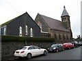
Lissara Presbyterian Church in Market Square
This image was taken from Market Street. The present church dates from 1865 and occupies the site of the first church built in 1770 at a cost of £300.
Image: © Eric Jones
Taken: 25 Nov 2015
0.07 miles