IMAGES TAKEN NEAR TO
Lislea Drive, DOWNPATRICK, BT30 9DB
Introduction
This page details the photographs taken nearby to Lislea Drive, BT30 9DB by members of the Geograph project.
The Geograph project started in 2005 with the aim of publishing, organising and preserving representative images for every square kilometre of Great Britain, Ireland and the Isle of Man.

There are currently over 7.5m images from over14,400 individuals and you can help contribute to the project by visiting https://www.geograph.org.uk
Image Map
Images are licensed for reuse under creativecommons.org/licenses/by-sa/2.0
Notes
- Clicking on the map will re-center to the selected point.
- The higher the marker number, the further away the image location is from the centre of the postcode.
Image Listing (58 Images Found)
Images are licensed for reuse under creativecommons.org/licenses/by-sa/2.0
Image
Details
Distance
2
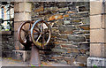
Old pump, Crossgar
The same pump, with hand wheel, previously seen in Image I’d hoped that it might have an inscription showing the maker’s name or date of manufacture but, if it does, I couldn’t find one.
Image: © Albert Bridge
Taken: 25 Mar 2011
0.09 miles
3
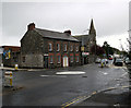
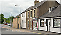
Downpatrick Street, Crossgar
The junction of Downpatrick Street (ahead) and Killyleagh Street (left) in Crossgar.
Image: © Rossographer
Taken: 23 Oct 2010
0.10 miles
4
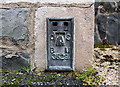
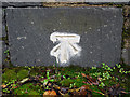
Flush Bracket, Crossgar
Flush bracket located on the north-western tip of the Church of the Immaculate Conception and Saint Joseph, Downpatrick Street, Crossgar Image
The number on the bracket is OSBM 3529.
The mark is 20.41 metres above MSL.
A flush bracket is a type of bench mark set onto the face of a building. See also http://www.geograph.org.uk/search.php?i=11037856 for many other examples I have found.
Image: © Rossographer
Taken: 23 Oct 2010
0.11 miles
5
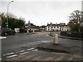
The junction of the Killyleagh Road and the A7 in the centre of Crossgar
The bridge carries the A7 over the Glasswater River. The Glasswater River is a tributary of the Quoile.
Image: © Eric Jones
Taken: 25 Nov 2015
0.11 miles
6
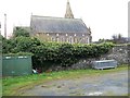
Church of the Immaculate Conception and St Joseph's, Crossgar
The present church was built in 1867 on the site of an earlier chapel erected in 1798.
Image: © Eric Jones
Taken: 25 Nov 2015
0.12 miles
7
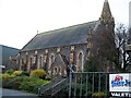
The Church of the Immaculate Conception and St Joseph's, Crossgar
Erected in 1867 this church stands in Downpatrick Street.
Image: © Eric Jones
Taken: 25 Nov 2015
0.12 miles
8
Bench Mark, Crossgar
Cut bench mark on Everogue's Bridge, Crossgar.
The mark is 18.48 metres above MSL.
Image: © Rossographer
Taken: 23 Oct 2010
0.12 miles
9
The Kilmore Road, Crossgar
The Crossgar end of the minor road from Kilmore Image
Image: © Albert Bridge
Taken: 13 Jun 2013
0.12 miles
10
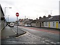
View west along Killyleagh Road
The image was taken from the corner of James Street.
Image: © Eric Jones
Taken: 25 Nov 2015
0.12 miles