IMAGES TAKEN NEAR TO
Inch Abbey Road, DOWNPATRICK, BT30 9AT
Introduction
This page details the photographs taken nearby to Inch Abbey Road, BT30 9AT by members of the Geograph project.
The Geograph project started in 2005 with the aim of publishing, organising and preserving representative images for every square kilometre of Great Britain, Ireland and the Isle of Man.

There are currently over 7.5m images from over14,400 individuals and you can help contribute to the project by visiting https://www.geograph.org.uk
Image Map
Images are licensed for reuse under creativecommons.org/licenses/by-sa/2.0
Notes
- Clicking on the map will re-center to the selected point.
- The higher the marker number, the further away the image location is from the centre of the postcode.
Image Listing (2 Images Found)
Images are licensed for reuse under creativecommons.org/licenses/by-sa/2.0
Image
Details
Distance
1
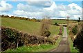
The Inch Abbey Road near Downpatrick (2)
See Image The road, in this square, as it makes its way north through drumlin country. Continue to Image
Image: © Albert Bridge
Taken: 27 Mar 2008
0.18 miles
2
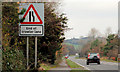
Crawler lane near Downpatrick (4)
The “End of Crawler Lane” sign at the end of the northbound crawler lane on the Belfast Road.
Image: © Albert Bridge
Taken: 20 Nov 2010
0.24 miles