IMAGES TAKEN NEAR TO
Ballylucas Road, DOWNPATRICK, BT30 8SZ
Introduction
This page details the photographs taken nearby to Ballylucas Road, BT30 8SZ by members of the Geograph project.
The Geograph project started in 2005 with the aim of publishing, organising and preserving representative images for every square kilometre of Great Britain, Ireland and the Isle of Man.

There are currently over 7.5m images from over14,400 individuals and you can help contribute to the project by visiting https://www.geograph.org.uk
Image Map
Images are licensed for reuse under creativecommons.org/licenses/by-sa/2.0
Notes
- Clicking on the map will re-center to the selected point.
- The higher the marker number, the further away the image location is from the centre of the postcode.
Image Listing (11 Images Found)
Images are licensed for reuse under creativecommons.org/licenses/by-sa/2.0
Image
Details
Distance
1
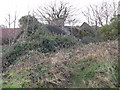
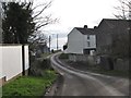
"The House of Horrors" - a derelict cottage at Scollogstown
This cottage, described by the Belfast Telegraph as the "House of Horrors", was the site of crimes against young boys from the Falls Road area of Belfast by Roman Catholic priest Daniel Curran, from the mid-70s to the early 1990s.
http://www.channel4.com/news/paedophile-priest-is-sentenced-to-four-years
http://www.catholicabusesurvivorsni.com/?p=1173
Image: © Eric Jones
Taken: 7 Feb 2012
0.09 miles
2
View south eastwards towards St John's Point from Scollogstown
Image: © Eric Jones
Taken: 7 Feb 2012
0.11 miles
3
Traditional farmhouse on the Ballylucas Road
Image: © Eric Jones
Taken: 7 Feb 2012
0.14 miles
4
Scollogstown
In this view along Ballylucas Road the sea can be seen in the background.
Image: © Eric Jones
Taken: 7 Feb 2012
0.15 miles
5
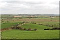
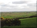
Drumlins and boglands east of the Ballylucas Road
Image: © Eric Jones
Taken: 7 Feb 2012
0.17 miles
6
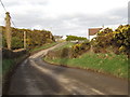
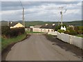
Entering Scollogstown along the Ballylucas Road
Scollogstown is a rural hamlet set along the Ballylucas Road.
Image: © Eric Jones
Taken: 7 Feb 2012
0.18 miles
7
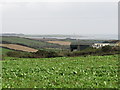
Farmland south of Corbally Road
The view extends south eastwards in the direction of St John's Point, with its well-known lighthouse.
Image: © Eric Jones
Taken: 4 Oct 2011
0.19 miles
8
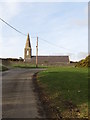
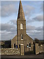
Approaching Rathmullan Church from the south along Ballylucas Road
The Ballylucas Road is the name for the southern stretch of the rural road which links the A2 coastal road with Downpatrick.
Image: © Eric Jones
Taken: 7 Feb 2012
0.23 miles
9
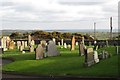
The grave yard at Rathmullan CoI Parish Church
The churchyard overlooks the North Irish Sea. The lighthouse at St John's Point can be seen in the background.
Image: © Eric Jones
Taken: 7 Feb 2012
0.23 miles