IMAGES TAKEN NEAR TO
Clanmaghery Road, DOWNPATRICK, BT30 8SU
Introduction
This page details the photographs taken nearby to Clanmaghery Road, BT30 8SU by members of the Geograph project.
The Geograph project started in 2005 with the aim of publishing, organising and preserving representative images for every square kilometre of Great Britain, Ireland and the Isle of Man.

There are currently over 7.5m images from over14,400 individuals and you can help contribute to the project by visiting https://www.geograph.org.uk
Image Map
Images are licensed for reuse under creativecommons.org/licenses/by-sa/2.0
Notes
- Clicking on the map will re-center to the selected point.
- The higher the marker number, the further away the image location is from the centre of the postcode.
Image Listing (4 Images Found)
Images are licensed for reuse under creativecommons.org/licenses/by-sa/2.0
Image
Details
Distance

3
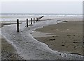
Stream discharging into the Irish Sea on the western side of Tyrella Beach
Image: © Eric Jones
Taken: 31 Jan 2012
0.21 miles
4
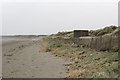
World War II Pillbox at the edge of the dunes at Tyrella
The gun apertures and entrance to the pill box have been bricked up.
Image: © Eric Jones
Taken: 31 Jan 2012
0.23 miles