IMAGES TAKEN NEAR TO
Drumanaghan Road, DOWNPATRICK, BT30 8RY
Introduction
This page details the photographs taken nearby to Drumanaghan Road, BT30 8RY by members of the Geograph project.
The Geograph project started in 2005 with the aim of publishing, organising and preserving representative images for every square kilometre of Great Britain, Ireland and the Isle of Man.

There are currently over 7.5m images from over14,400 individuals and you can help contribute to the project by visiting https://www.geograph.org.uk
Image Map
Images are licensed for reuse under creativecommons.org/licenses/by-sa/2.0
Notes
- Clicking on the map will re-center to the selected point.
- The higher the marker number, the further away the image location is from the centre of the postcode.
Image Listing (5 Images Found)
Images are licensed for reuse under creativecommons.org/licenses/by-sa/2.0
Image
Details
Distance
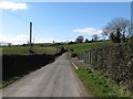
2
Farm house and outbuildings on either side of Drumanaghan Road
The image is taken in a north-easterly direction. A large drumlin forms the background.
Image: © Eric Jones
Taken: 10 Mar 2015
0.08 miles
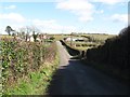
3
Approaching a sharp bend in the junction with Drumanaghan Road
Image: © Eric Jones
Taken: 10 Mar 2015
0.09 miles
4
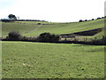
Disused gravel pit off Drumanaghan Road
This is at the base of a drumlin.
Image: © Eric Jones
Taken: 10 Mar 2015
0.14 miles
5
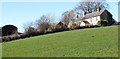
Farmhouse and outbuildings above the Drumanaghan Road
This farmhouse is known as Drumanaghan House.
Image: © Eric Jones
Taken: 10 Mar 2015
0.20 miles