IMAGES TAKEN NEAR TO
Drumcaw Road, DOWNPATRICK, BT30 8RX
Introduction
This page details the photographs taken nearby to Drumcaw Road, BT30 8RX by members of the Geograph project.
The Geograph project started in 2005 with the aim of publishing, organising and preserving representative images for every square kilometre of Great Britain, Ireland and the Isle of Man.

There are currently over 7.5m images from over14,400 individuals and you can help contribute to the project by visiting https://www.geograph.org.uk
Image Map
Images are licensed for reuse under creativecommons.org/licenses/by-sa/2.0
Notes
- Clicking on the map will re-center to the selected point.
- The higher the marker number, the further away the image location is from the centre of the postcode.
Image Listing (2 Images Found)
Images are licensed for reuse under creativecommons.org/licenses/by-sa/2.0
Image
Details
Distance
1
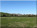
Houses in drumlin country with the Slieve Croob range in the background
The lowlands between the Mourne Mountains and the Slieve Croob Range are covered by a carpet of glacial debris which was shaped into a drumlin field which exhibits the classic "basket of eggs" topography. These drumlins are young -about 13,000 years old. The Slieve Croob Range, on the other hand, is a much older feature - being some 400 million years old,
Image: © Eric Jones
Taken: 10 Mar 2015
0.07 miles
2
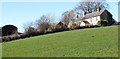
Farmhouse and outbuildings above the Drumanaghan Road
This farmhouse is known as Drumanaghan House.
Image: © Eric Jones
Taken: 10 Mar 2015
0.24 miles