IMAGES TAKEN NEAR TO
Manse Road, DOWNPATRICK, BT30 8RH
Introduction
This page details the photographs taken nearby to Manse Road, BT30 8RH by members of the Geograph project.
The Geograph project started in 2005 with the aim of publishing, organising and preserving representative images for every square kilometre of Great Britain, Ireland and the Isle of Man.

There are currently over 7.5m images from over14,400 individuals and you can help contribute to the project by visiting https://www.geograph.org.uk
Image Map
Images are licensed for reuse under creativecommons.org/licenses/by-sa/2.0
Notes
- Clicking on the map will re-center to the selected point.
- The higher the marker number, the further away the image location is from the centre of the postcode.
Image Listing (31 Images Found)
Images are licensed for reuse under creativecommons.org/licenses/by-sa/2.0
Image
Details
Distance
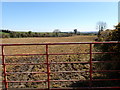
3
Drumcaw Townland
Looking south-east from Manse Road
Image: © Kenneth Allen
Taken: 31 Aug 2011
0.04 miles
4
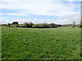
Cultivated grass on the west side of Manse Road
Image: © Eric Jones
Taken: 19 Apr 2018
0.04 miles
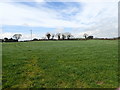
5
Soft going in the field
The wet spring and the resultant slow rate of grass growth has led in many parts of Ireland to the trampling of paddocks used by store cattle and dairy herds with resultant sward damage. In recent days, with improving weather conditions grass growth has accelerated.
https://www.agriland.ie/farming-news/damaged-swards-can-they-recover/
https://www.agriland.ie/farming-news/back-on-track-grass-growth-rates-expected-to-soar/
Image: © Eric Jones
Taken: 19 Apr 2018
0.07 miles
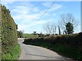
6
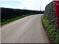
View South to a right hand bend on Manse Road
The hedge on the right is that of Drumcaw Villa. The summits of the High Mournes can be seen in the far distance.
Image: © Eric Jones
Taken: 19 Apr 2018
0.07 miles
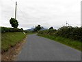
7
View North-West along Manse Road, Seaforde
Image: © Eric Jones
Taken: 19 Apr 2018
0.08 miles
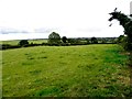
8
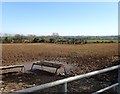
Heavily trampled fields on the south side of Manse Road
The wet spring and the resultant slow rate of grass growth has led in many parts of Ireland to the trampling of paddocks used by store cattle and dairy herds with resultant sward damage. In recent days, with improving weather conditions grass growth has accelerated.
https://www.agriland.ie/farming-news/damaged-swards-can-they-recover/
https://www.agriland.ie/farming-news/back-on-track-grass-growth-rates-expected-to-soar/
Image: © Eric Jones
Taken: 19 Apr 2018
0.08 miles
9
Drumlin landscape West of the Manse Road
Image: © Eric Jones
Taken: 19 Apr 2018
0.11 miles
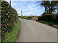
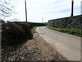
10
Meandering section of Manse Road, Seaforde
The wall in the middle distance is that at the entrance to the drive of Drumcaw Villa.
Image: © Eric Jones
Taken: 19 Apr 2018
0.12 miles