IMAGES TAKEN NEAR TO
Knocksticken Road, DOWNPATRICK, BT30 8RE
Introduction
This page details the photographs taken nearby to Knocksticken Road, BT30 8RE by members of the Geograph project.
The Geograph project started in 2005 with the aim of publishing, organising and preserving representative images for every square kilometre of Great Britain, Ireland and the Isle of Man.

There are currently over 7.5m images from over14,400 individuals and you can help contribute to the project by visiting https://www.geograph.org.uk
Image Map
Images are licensed for reuse under creativecommons.org/licenses/by-sa/2.0
Notes
- Clicking on the map will re-center to the selected point.
- The higher the marker number, the further away the image location is from the centre of the postcode.
Image Listing (1 Images Found)
Images are licensed for reuse under creativecommons.org/licenses/by-sa/2.0
Image
Details
Distance
1
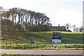
The ruined Mount Panther House
This historic estate, now on sale, is heralded as "A once in a lifetime opportunity". The main house, however, needs some work done before it is again inhabitable. The price tag is in the region of £4-5 million.
http://lordbelmontinnorthernireland.blogspot.com/2008/04/brief-history-of-mount-panther-county.html
Image: © Eric Jones
Taken: 12 Nov 2010
0.24 miles