IMAGES TAKEN NEAR TO
The Heights, DOWNPATRICK, BT30 8PY
Introduction
This page details the photographs taken nearby to The Heights, BT30 8PY by members of the Geograph project.
The Geograph project started in 2005 with the aim of publishing, organising and preserving representative images for every square kilometre of Great Britain, Ireland and the Isle of Man.

There are currently over 7.5m images from over14,400 individuals and you can help contribute to the project by visiting https://www.geograph.org.uk
Image Map
Images are licensed for reuse under creativecommons.org/licenses/by-sa/2.0
Notes
- Clicking on the map will re-center to the selected point.
- The higher the marker number, the further away the image location is from the centre of the postcode.
Image Listing (6 Images Found)
Images are licensed for reuse under creativecommons.org/licenses/by-sa/2.0
Image
Details
Distance
1
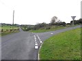
Crawfordsburn Road
Heading north-west; The Heights Road branches off to the right.
Image: © Kenneth Allen
Taken: 3 Oct 2011
0.16 miles
2
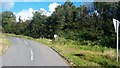
The eastern section of The Heights Road at its junction with Crawfordstown Road
Image: © Eric Jones
Taken: 12 Oct 2012
0.17 miles
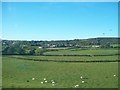
5
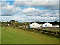
The Teconnaught GAA Club House
This is situated on Teconnaught Road in a rural area between Drumaness and Loughinisland.
Image: © Eric Jones
Taken: 12 Oct 2012
0.24 miles
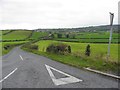
6
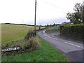
Teconnaught Road
Heading north from Crawfordsburn Road
Image: © Kenneth Allen
Taken: 3 Oct 2011
0.25 miles