IMAGES TAKEN NEAR TO
Drumgooland Road, DOWNPATRICK, BT30 8NT
Introduction
This page details the photographs taken nearby to Drumgooland Road, BT30 8NT by members of the Geograph project.
The Geograph project started in 2005 with the aim of publishing, organising and preserving representative images for every square kilometre of Great Britain, Ireland and the Isle of Man.

There are currently over 7.5m images from over14,400 individuals and you can help contribute to the project by visiting https://www.geograph.org.uk
Image Map
Images are licensed for reuse under creativecommons.org/licenses/by-sa/2.0
Notes
- Clicking on the map will re-center to the selected point.
- The higher the marker number, the further away the image location is from the centre of the postcode.
Image Listing (6 Images Found)
Images are licensed for reuse under creativecommons.org/licenses/by-sa/2.0
Image
Details
Distance
1
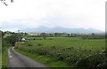
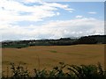
Croplands on the Seaforde Demesne
The Mourne Mountains form the background.
Image: © Eric Jones
Taken: 9 Jul 2011
0.04 miles
2
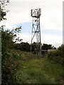
Telecommunications Mast off Drumgooland Road
Image: © Eric Jones
Taken: 9 Jul 2011
0.06 miles
3
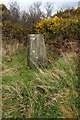
Triangulation Pillar
This is not easy to find on the ground as it is surrounded by high gorse and brambles. It is an easy walk up from the road to the west, but since all the views have been obscured it is hardly worth while..
Image: © James Carroll
Taken: 26 Mar 2008
0.15 miles
4
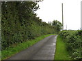
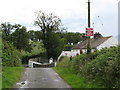
Drumgooland Road south of the Seaforde-Drumgooland Road Crossroads
The top of the telecommunications mast can be seen through the trees.
Image: © Eric Jones
Taken: 9 Jul 2011
0.15 miles
5
Cropland west of Drumgooland Road
This is an important crop growing area, Cereals and potatoes are the main crops. At one time flax was a major crop. Hills of the Slieve Croob range can be seen in the background.
Image: © Eric Jones
Taken: 9 Jul 2011
0.17 miles
6
The home of the East Down Hunt
The East Down Hunt has been active for some two hundred and fifty years. The pack is made up of Modern English Foxhounds.
http://www.eastdownhunt.co.uk/index.php
Image: © Eric Jones
Taken: 9 Jul 2011
0.22 miles