IMAGES TAKEN NEAR TO
Creeghduff Road, DOWNPATRICK, BT30 8NJ
Introduction
This page details the photographs taken nearby to Creeghduff Road, BT30 8NJ by members of the Geograph project.
The Geograph project started in 2005 with the aim of publishing, organising and preserving representative images for every square kilometre of Great Britain, Ireland and the Isle of Man.

There are currently over 7.5m images from over14,400 individuals and you can help contribute to the project by visiting https://www.geograph.org.uk
Image Map
Images are licensed for reuse under creativecommons.org/licenses/by-sa/2.0
Notes
- Clicking on the map will re-center to the selected point.
- The higher the marker number, the further away the image location is from the centre of the postcode.
Image Listing (6 Images Found)
Images are licensed for reuse under creativecommons.org/licenses/by-sa/2.0
Image
Details
Distance
1
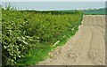
Countryside near Clough
A ploughed field and the first of the hawthorn blossom at Creeghduff near Clough.
Image: © Albert Bridge
Taken: 12 May 2008
0.10 miles
2
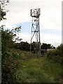
Telecommunications Mast off Drumgooland Road
Image: © Eric Jones
Taken: 9 Jul 2011
0.22 miles
3
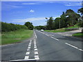
Road Junction
Creeghduff Road joins the A25 Newcastle to Downpatrick road. Looking towards Downpatrick.
Image: © Brian Shaw
Taken: 10 Jul 2006
0.23 miles
4
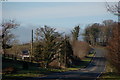
Downpatrick-Clough road near Tullymurry
Much of the Downpatrick-Newcastle road as far as Clough is twisting. This section, just beyond the Tullymurry Bridge is an exception. It can be a bit of a racetrack. The view is towards Clough.
Image: © Albert Bridge
Taken: 17 Feb 2007
0.23 miles
5
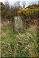
Triangulation Pillar
This is not easy to find on the ground as it is surrounded by high gorse and brambles. It is an easy walk up from the road to the west, but since all the views have been obscured it is hardly worth while..
Image: © James Carroll
Taken: 26 Mar 2008
0.23 miles
6
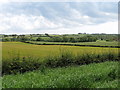
View across farmland towards the Blackstaff Valley
The image was taken from the Creeghduff Road.
Image: © Eric Jones
Taken: 9 Jul 2011
0.24 miles