IMAGES TAKEN NEAR TO
Farranfad Road, DOWNPATRICK, BT30 8NH
Introduction
This page details the photographs taken nearby to Farranfad Road, BT30 8NH by members of the Geograph project.
The Geograph project started in 2005 with the aim of publishing, organising and preserving representative images for every square kilometre of Great Britain, Ireland and the Isle of Man.

There are currently over 7.5m images from over14,400 individuals and you can help contribute to the project by visiting https://www.geograph.org.uk
Image Map
Images are licensed for reuse under creativecommons.org/licenses/by-sa/2.0
Notes
- Clicking on the map will re-center to the selected point.
- The higher the marker number, the further away the image location is from the centre of the postcode.
Image Listing (7 Images Found)
Images are licensed for reuse under creativecommons.org/licenses/by-sa/2.0
Image
Details
Distance
1
Entrance to the depot of Crossgar Food Services off the Farranfad Road
Image: © Eric Jones
Taken: 9 Jul 2011
0.10 miles
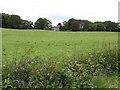
3
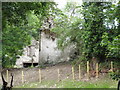
Ruined farm buildings at Farranfad near Seaforde
Image: © Eric Jones
Taken: 9 Jul 2011
0.12 miles
4
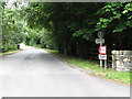
Farranfad Road near Seaforde - at the Forest
Outside Farranfad Wood.
Image: © Dean Molyneaux
Taken: 6 Sep 2009
0.15 miles
5
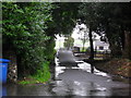
Villa in Farranfad Wood
The image was taken from the Farranfad Road.
Image: © Eric Jones
Taken: 9 Jul 2011
0.15 miles
6
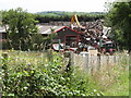
The Seaforde Metals Scrap Yard on Farranfad Road
Image: © Eric Jones
Taken: 9 Jul 2011
0.23 miles
7
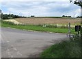
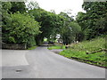
The entrance to Farranfad Road from Creeghaduff Road
Image: © Eric Jones
Taken: 9 Jul 2011
0.25 miles