IMAGES TAKEN NEAR TO
Coniamstown Road, DOWNPATRICK, BT30 8LU
Introduction
This page details the photographs taken nearby to Coniamstown Road, BT30 8LU by members of the Geograph project.
The Geograph project started in 2005 with the aim of publishing, organising and preserving representative images for every square kilometre of Great Britain, Ireland and the Isle of Man.

There are currently over 7.5m images from over14,400 individuals and you can help contribute to the project by visiting https://www.geograph.org.uk
Image Map
Images are licensed for reuse under creativecommons.org/licenses/by-sa/2.0
Notes
- Clicking on the map will re-center to the selected point.
- The higher the marker number, the further away the image location is from the centre of the postcode.
Image Listing (3 Images Found)
Images are licensed for reuse under creativecommons.org/licenses/by-sa/2.0
Image
Details
Distance
1
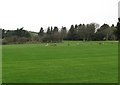
Bright Castle Golf Course
This is a hilly parkland 18 hole course situated in the shadow of Castle Bright.
Image: © Eric Jones
Taken: 31 Jan 2012
0.19 miles
2
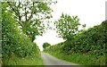
The Coniamstown Road near Killough
A minor road running from Bright towards Downpatrick. Bright Castle is at the end of the road on the right. Bright Castle Golf Club is behind the hedge on the right.
Image: © Albert Bridge
Taken: 14 Jul 2008
0.21 miles
3
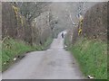
Horserider on the undulating Comiamstown Road
Image: © Eric Jones
Taken: 31 Jan 2012
0.21 miles