IMAGES TAKEN NEAR TO
Ballylig Road, DOWNPATRICK, BT30 8LG
Introduction
This page details the photographs taken nearby to Ballylig Road, BT30 8LG by members of the Geograph project.
The Geograph project started in 2005 with the aim of publishing, organising and preserving representative images for every square kilometre of Great Britain, Ireland and the Isle of Man.

There are currently over 7.5m images from over14,400 individuals and you can help contribute to the project by visiting https://www.geograph.org.uk
Image Map
Images are licensed for reuse under creativecommons.org/licenses/by-sa/2.0
Notes
- Clicking on the map will re-center to the selected point.
- The higher the marker number, the further away the image location is from the centre of the postcode.
Image Listing (2 Images Found)
Images are licensed for reuse under creativecommons.org/licenses/by-sa/2.0
Image
Details
Distance
2
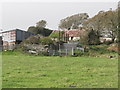
Ballylig Farmhouse, Ballylig Road
This is one few traditional farmhouses to have survived in the area. Indeed, throughout Northern Ireland traditional farmhouses have been abandoned or demolished to be replaced by modern, comfortable, but characterless, bungalows.
Image: © Eric Jones
Taken: 28 Sep 2011
0.16 miles