IMAGES TAKEN NEAR TO
Farranfad Road, DOWNPATRICK, BT30 8JD
Introduction
This page details the photographs taken nearby to Farranfad Road, BT30 8JD by members of the Geograph project.
The Geograph project started in 2005 with the aim of publishing, organising and preserving representative images for every square kilometre of Great Britain, Ireland and the Isle of Man.

There are currently over 7.5m images from over14,400 individuals and you can help contribute to the project by visiting https://www.geograph.org.uk
Image Map
Images are licensed for reuse under creativecommons.org/licenses/by-sa/2.0
Notes
- Clicking on the map will re-center to the selected point.
- The higher the marker number, the further away the image location is from the centre of the postcode.
Image Listing (5 Images Found)
Images are licensed for reuse under creativecommons.org/licenses/by-sa/2.0
Image
Details
Distance
1
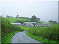
Farranfad Road near Seaforde
In the townland of Farranfad - leading to Seaforde.
Image: © Dean Molyneaux
Taken: 6 Sep 2009
0.01 miles
2
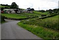
Farmhouse on the Farranfad Road
The Farranfad Road leads in the direction of the village of Seaforde.
Image: © Eric Jones
Taken: 9 Jul 2011
0.02 miles
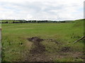
3

Farranfad Road ascending across a drumlin
The road has been directed away from the flat marshy land to the north.
Image: © Eric Jones
Taken: 9 Jul 2011
0.07 miles
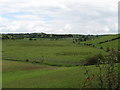
4
Reclaimed wetlands to the north of the Farranfad Road
This inter-drumlin flat land has been reclaimed for farming.
Image: © Eric Jones
Taken: 9 Jul 2011
0.09 miles
5
Reclaimed wetland north of the Farranfad Road
Image: © Eric Jones
Taken: 9 Jul 2011
0.10 miles