IMAGES TAKEN NEAR TO
Lake Road, DOWNPATRICK, BT30 8HY
Introduction
This page details the photographs taken nearby to Lake Road, BT30 8HY by members of the Geograph project.
The Geograph project started in 2005 with the aim of publishing, organising and preserving representative images for every square kilometre of Great Britain, Ireland and the Isle of Man.

There are currently over 7.5m images from over14,400 individuals and you can help contribute to the project by visiting https://www.geograph.org.uk
Image Map
Images are licensed for reuse under creativecommons.org/licenses/by-sa/2.0
Notes
- Clicking on the map will re-center to the selected point.
- The higher the marker number, the further away the image location is from the centre of the postcode.
Image Listing (5 Images Found)
Images are licensed for reuse under creativecommons.org/licenses/by-sa/2.0
Image
Details
Distance
1
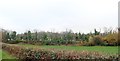
The embankment of the former Belfast and Co Down Railway on the north side of Ballydugan Lake
The image was taken from the Woodgrange Road. A short distance to the east the railway crossed the Woodgrange Road.
https://www.revolvy.com/page/Belfast-and-County-Down-Railway
Image: © Eric Jones
Taken: 17 Nov 2018
0.20 miles
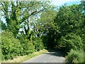
3
View westwards along Woodgrange Road on the north side of Ballydugan Lake
This is a well wooded area. Trees hide the lake from the road.
Image: © Eric Jones
Taken: 2 Oct 2014
0.22 miles
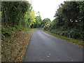
5
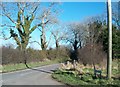
The entrance to Lake Road, Ballydugan
This road leads past Ballydugan Lake.
Image: © Eric Jones
Taken: 1 Mar 2011
0.25 miles