IMAGES TAKEN NEAR TO
Vianstown Road, DOWNPATRICK, BT30 8HW
Introduction
This page details the photographs taken nearby to Vianstown Road, BT30 8HW by members of the Geograph project.
The Geograph project started in 2005 with the aim of publishing, organising and preserving representative images for every square kilometre of Great Britain, Ireland and the Isle of Man.

There are currently over 7.5m images from over14,400 individuals and you can help contribute to the project by visiting https://www.geograph.org.uk
Image Map
Images are licensed for reuse under creativecommons.org/licenses/by-sa/2.0
Notes
- Clicking on the map will re-center to the selected point.
- The higher the marker number, the further away the image location is from the centre of the postcode.
Image Listing (9 Images Found)
Images are licensed for reuse under creativecommons.org/licenses/by-sa/2.0
Image
Details
Distance
2
View west along Erenagh Road with The Mournes in the background
Image: © Eric Jones
Taken: 4 Oct 2011
0.09 miles
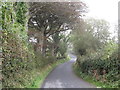
3
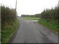
The Erenagh Road at the junction with Castlescreen Road, Castleskreen
Image: © Eric Jones
Taken: 29 Sep 2011
0.13 miles
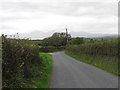
4
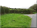
The Castlescreen Road turnoff on the Erenagh Road
Image: © Eric Jones
Taken: 4 Oct 2011
0.14 miles
6
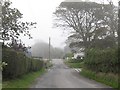
The Erenagh Road Junction on the Vianstown Road
Image: © Eric Jones
Taken: 29 Sep 2011
0.18 miles
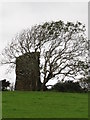
7
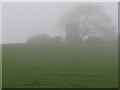
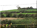
Castle Skreen - Hidden in the Mists of Time
This is the mysterious Castle Skreen, a medieval tower house built on a rath dating back to the Dark Ages.
http://irishantiquities.bravehost.com/down/castleskreen/castleskreen.html
Image: © Eric Jones
Taken: 29 Sep 2011
0.20 miles