IMAGES TAKEN NEAR TO
Tobercorran Road, DOWNPATRICK, BT30 8HU
Introduction
This page details the photographs taken nearby to Tobercorran Road, BT30 8HU by members of the Geograph project.
The Geograph project started in 2005 with the aim of publishing, organising and preserving representative images for every square kilometre of Great Britain, Ireland and the Isle of Man.

There are currently over 7.5m images from over14,400 individuals and you can help contribute to the project by visiting https://www.geograph.org.uk
Image Map
Images are licensed for reuse under creativecommons.org/licenses/by-sa/2.0
Notes
- Clicking on the map will re-center to the selected point.
- The higher the marker number, the further away the image location is from the centre of the postcode.
Image Listing (4 Images Found)
Images are licensed for reuse under creativecommons.org/licenses/by-sa/2.0
Image
Details
Distance
1
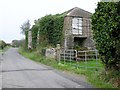
Derelict farm building on the southern section of Tobercorran Road
This is one of a group of buildings associated with a farmstead whose land has long been absorbed by a neighbouring farm.
Image: © Eric Jones
Taken: 29 Sep 2011
0.14 miles
2
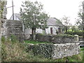
Derelict farm cottage alongside the Tobercorran Road
Image: © Eric Jones
Taken: 29 Sep 2011
0.15 miles
3
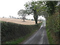
Harvested field on a drumlin slope above the Tobercorran Road
Image: © Eric Jones
Taken: 29 Sep 2011
0.23 miles
4
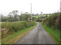
The Tobercorran Road north of the Down Council's Dog Kennels
Image: © Eric Jones
Taken: 29 Sep 2011
0.23 miles