IMAGES TAKEN NEAR TO
Point Road, DOWNPATRICK, BT30 8HT
Introduction
This page details the photographs taken nearby to Point Road, BT30 8HT by members of the Geograph project.
The Geograph project started in 2005 with the aim of publishing, organising and preserving representative images for every square kilometre of Great Britain, Ireland and the Isle of Man.

There are currently over 7.5m images from over14,400 individuals and you can help contribute to the project by visiting https://www.geograph.org.uk
Image Map
Images are licensed for reuse under creativecommons.org/licenses/by-sa/2.0
Notes
- Clicking on the map will re-center to the selected point.
- The higher the marker number, the further away the image location is from the centre of the postcode.
Image Listing (5 Images Found)
Images are licensed for reuse under creativecommons.org/licenses/by-sa/2.0
Image
Details
Distance
1
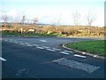
The mouth of the Point Road seen from the A2
Image: © Eric Jones
Taken: 12 Nov 2010
0.14 miles
2
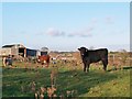
Cattle and farm buildings north of the Four Roads Crossroads
Image: © Eric Jones
Taken: 12 Nov 2010
0.17 miles
3
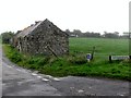
Derelict homestead at the junction of Tobercorran and Point Roads
Image: © Eric Jones
Taken: 29 Sep 2011
0.18 miles
4
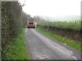
Down District Council refuse lorry on Tobercorran Road
Image: © Eric Jones
Taken: 29 Sep 2011
0.23 miles
5
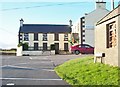
The Four Roads Inn, Carrickinab, Ballykinler
Located at the crossroads of the Carrickinab Road and the A2, The Four Roads Inn is a popular venue with live music performances, bingo, discos and quizzes.
Image: © Eric Jones
Taken: 12 Nov 2010
0.23 miles