IMAGES TAKEN NEAR TO
Ballykilbeg Road, DOWNPATRICK, BT30 8HJ
Introduction
This page details the photographs taken nearby to Ballykilbeg Road, BT30 8HJ by members of the Geograph project.
The Geograph project started in 2005 with the aim of publishing, organising and preserving representative images for every square kilometre of Great Britain, Ireland and the Isle of Man.

There are currently over 7.5m images from over14,400 individuals and you can help contribute to the project by visiting https://www.geograph.org.uk
Image Map
Images are licensed for reuse under creativecommons.org/licenses/by-sa/2.0
Notes
- Clicking on the map will re-center to the selected point.
- The higher the marker number, the further away the image location is from the centre of the postcode.
Image Listing (6 Images Found)
Images are licensed for reuse under creativecommons.org/licenses/by-sa/2.0
Image
Details
Distance
1
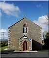
St Malachy's, Ballykilbeg
St Malachy's RC church at Ballykilbeg near Clough. The church dates from c1745. See also Image for a closer look at the porch, including a blue plaque to Dr William Crolly.
Image: © Rossographer
Taken: 27 Mar 2010
0.12 miles
2
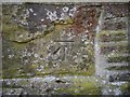
Bench Mark, Ballykilbeg
Cut bench mark located the western side of St Malachy's, Ballykilbeg Image
The mark is 18.97 metres above MSL.
See also http://www.geograph.org.uk/search.php?i=11037856 for many other examples I have found.
Image: © Rossographer
Taken: 27 Mar 2010
0.12 miles
3
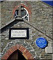
St Malachy's, Ballykilbeg [detail]
Detail of the front of St Malachy's RC church, Ballykilbeg Image Included on the front porch are a stone marking dates that, I presume, relate to the founding of the church (1745) and later alterations or reconstructions to the building. Further information on the church welcomed.
Alongside this is a blue plaque to Dr William Crolly who was born in Ballykilbeg on 8th June 1780. Dr Crolly founded St Malachy's College in Belfast in 1833 Image and was appointed Archbishop of Armagh in 1838. For more information see http://www.ulsterhistory.co.uk/crolly.htm and for a report on the unveiling of the plaque see http://www.ulsterhistory.co.uk/010604.htm .
Image: © Rossographer
Taken: 27 Mar 2010
0.12 miles
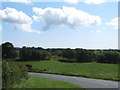
4
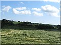
Cropland immediately east of the Ballykillbeg junction on the A25
Image: © Eric Jones
Taken: 29 Jul 2011
0.17 miles
6
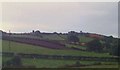
Drumlin land east of the Ballykilbeg Road
Image: © Eric Jones
Taken: 20 Aug 2009
0.25 miles