IMAGES TAKEN NEAR TO
Ringsallin Gardens, DOWNPATRICK, BT30 8ER
Introduction
This page details the photographs taken nearby to Ringsallin Gardens, BT30 8ER by members of the Geograph project.
The Geograph project started in 2005 with the aim of publishing, organising and preserving representative images for every square kilometre of Great Britain, Ireland and the Isle of Man.

There are currently over 7.5m images from over14,400 individuals and you can help contribute to the project by visiting https://www.geograph.org.uk
Image Map
Images are licensed for reuse under creativecommons.org/licenses/by-sa/2.0
Notes
- Clicking on the map will re-center to the selected point.
- The higher the marker number, the further away the image location is from the centre of the postcode.
Image Listing (4 Images Found)
Images are licensed for reuse under creativecommons.org/licenses/by-sa/2.0
Image
Details
Distance
1
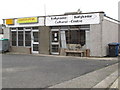
The Ballykinler/Ballykinlar Cultural Centre
This building stands on Commons Road. This small building is used for all types of social activity including art classes.
http://villageworks.org.uk/wp/?page_id=3
Image: © Eric Jones
Taken: 31 Jan 2012
0.07 miles
2
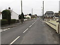
View west along Commons Road in the village of Ballykinler
This is a street familiar to thousands of servicemen. Ballykinler Garrison is located at the end of this street.
Image: © Eric Jones
Taken: 31 Jan 2012
0.09 miles
4

Slieve Donard through the Trees
The mountain of Slieve Donard (Image) Across the sports fields of Ballykinler army base.
Image: © Mick Garratt
Taken: 13 Sep 2009
0.23 miles