IMAGES TAKEN NEAR TO
Commons Road, DOWNPATRICK, BT30 8DH
Introduction
This page details the photographs taken nearby to Commons Road, BT30 8DH by members of the Geograph project.
The Geograph project started in 2005 with the aim of publishing, organising and preserving representative images for every square kilometre of Great Britain, Ireland and the Isle of Man.

There are currently over 7.5m images from over14,400 individuals and you can help contribute to the project by visiting https://www.geograph.org.uk
Image Map
Images are licensed for reuse under creativecommons.org/licenses/by-sa/2.0
Notes
- Clicking on the map will re-center to the selected point.
- The higher the marker number, the further away the image location is from the centre of the postcode.
Image Listing (9 Images Found)
Images are licensed for reuse under creativecommons.org/licenses/by-sa/2.0
Image
Details
Distance
1
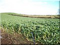
A field of brassicas east of the Commons Road
Image: © Eric Jones
Taken: 12 Nov 2010
0.03 miles
3
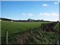
Sheep pastures alongside the Commons Road
The woodland at Carrickinab can be seen on the skyline.
Image: © Eric Jones
Taken: 12 Nov 2010
0.15 miles
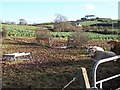
5
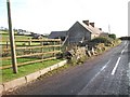
Disused farmstead on the Commons Road
New bungalows on the Carrickinab Road can be seen in the background.
Image: © Eric Jones
Taken: 12 Nov 2010
0.18 miles
7
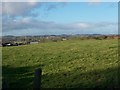
View north-westwards from the Carrickinab Road
This is a view in the direction of the Commons Road.
Image: © Eric Jones
Taken: 12 Nov 2010
0.21 miles
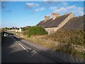
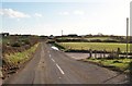
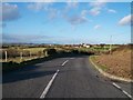
8
Bend in the Commons Road north of the Carrickinab crossroads
Image: © Eric Jones
Taken: 12 Nov 2010
0.21 miles
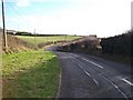
9
View north along the Commons Road from the crossroads with Carrickinab Road
The Lecale Way/Ulster Way path follows the Commons Road in the direction of the village of Ballykinler.
Image: © Eric Jones
Taken: 12 Nov 2010
0.24 miles