IMAGES TAKEN NEAR TO
Glen Road, DOWNPATRICK, BT30 8AY
Introduction
This page details the photographs taken nearby to Glen Road, BT30 8AY by members of the Geograph project.
The Geograph project started in 2005 with the aim of publishing, organising and preserving representative images for every square kilometre of Great Britain, Ireland and the Isle of Man.

There are currently over 7.5m images from over14,400 individuals and you can help contribute to the project by visiting https://www.geograph.org.uk
Image Map
Images are licensed for reuse under creativecommons.org/licenses/by-sa/2.0
Notes
- Clicking on the map will re-center to the selected point.
- The higher the marker number, the further away the image location is from the centre of the postcode.
Image Listing (4 Images Found)
Images are licensed for reuse under creativecommons.org/licenses/by-sa/2.0
Image
Details
Distance
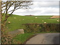
1
Glen Road climbing towards the summit ridge of Ballydargan Hill
Image: © Eric Jones
Taken: 7 Feb 2012
0.04 miles
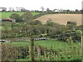
2
Wetland on the valley floor
The valley is drained by a stream flowing from Ballydargan Lake to enter the sea at Tyrella Bay
Image: © Eric Jones
Taken: 7 Feb 2012
0.14 miles