IMAGES TAKEN NEAR TO
Carrowbane Road, DOWNPATRICK, BT30 8AS
Introduction
This page details the photographs taken nearby to Carrowbane Road, BT30 8AS by members of the Geograph project.
The Geograph project started in 2005 with the aim of publishing, organising and preserving representative images for every square kilometre of Great Britain, Ireland and the Isle of Man.

There are currently over 7.5m images from over14,400 individuals and you can help contribute to the project by visiting https://www.geograph.org.uk
Image Map
Images are licensed for reuse under creativecommons.org/licenses/by-sa/2.0
Notes
- Clicking on the map will re-center to the selected point.
- The higher the marker number, the further away the image location is from the centre of the postcode.
Image Listing (5 Images Found)
Images are licensed for reuse under creativecommons.org/licenses/by-sa/2.0
Image
Details
Distance
1
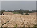
Potato fields on the north side of the Carrowbane Road
Image: © Eric Jones
Taken: 28 Sep 2011
0.06 miles
2
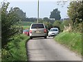
School-run traffic jam on the Carrowbane Road
It is going home time for the infants from St Patrick's Primary, Legamaddy.
Image: © Eric Jones
Taken: 28 Sep 2011
0.11 miles
3
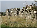
Derelict farmhouse on the Carrowbane Road
Image: © Eric Jones
Taken: 28 Sep 2011
0.12 miles