IMAGES TAKEN NEAR TO
Mill River Close, DOWNPATRICK, BT30 7WU
Introduction
This page details the photographs taken nearby to Mill River Close, BT30 7WU by members of the Geograph project.
The Geograph project started in 2005 with the aim of publishing, organising and preserving representative images for every square kilometre of Great Britain, Ireland and the Isle of Man.

There are currently over 7.5m images from over14,400 individuals and you can help contribute to the project by visiting https://www.geograph.org.uk
Image Map
Images are licensed for reuse under creativecommons.org/licenses/by-sa/2.0
Notes
- Clicking on the map will re-center to the selected point.
- The higher the marker number, the further away the image location is from the centre of the postcode.
Image Listing (21 Images Found)
Images are licensed for reuse under creativecommons.org/licenses/by-sa/2.0
Image
Details
Distance
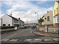
3
Strangford Road, Ardglass
Ardglass Bay to the right.
Image: © Dean Molyneaux
Taken: 20 Sep 2009
0.06 miles
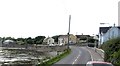
4
Recently built houses on Strangford Road, Ardglass
Image: © Eric Jones
Taken: 22 Jul 2013
0.07 miles
5
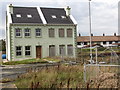
Semi-finished housing estate at Ardglass
This estate has been in the process of completion over a number of years.
Image: © Eric Jones
Taken: 23 Sep 2011
0.08 miles
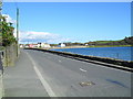
7
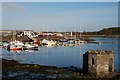
Ardglass marina
Ardglass marina at Phennick Cove. It opened in 1991.
Image: © Albert Bridge
Taken: 6 Nov 2007
0.11 miles
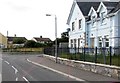
8
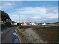
Houses overlooking the harbour at Ardglass
The road, Strangford Road, is designated the A2.
Image: © Eric Jones
Taken: 20 Aug 2009
0.11 miles
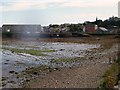
9
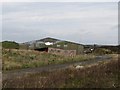
K fish plant at Ardglass
It is difficult to know whether this plant is still operational as the land between it and the coast road is now occupied by a partially finished housing estate.
Image: © Eric Jones
Taken: 23 Sep 2011
0.13 miles
10
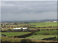
The K fish plant from Ardtole Church
The area west of the plant is mostly rough grazing land.
Image: © Eric Jones
Taken: 23 Sep 2011
0.13 miles