IMAGES TAKEN NEAR TO
Crew Road, DOWNPATRICK, BT30 7UJ
Introduction
This page details the photographs taken nearby to Crew Road, BT30 7UJ by members of the Geograph project.
The Geograph project started in 2005 with the aim of publishing, organising and preserving representative images for every square kilometre of Great Britain, Ireland and the Isle of Man.

There are currently over 7.5m images from over14,400 individuals and you can help contribute to the project by visiting https://www.geograph.org.uk
Image Map
Images are licensed for reuse under creativecommons.org/licenses/by-sa/2.0
Notes
- Clicking on the map will re-center to the selected point.
- The higher the marker number, the further away the image location is from the centre of the postcode.
Image Listing (5 Images Found)
Images are licensed for reuse under creativecommons.org/licenses/by-sa/2.0
Image
Details
Distance
1
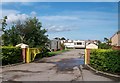
The Coney Island Caravan Park, Killough Road
This park is located just east of the Killough Bridge and about 1km from the hamlet of Coney Island.
Image: © Eric Jones
Taken: 20 Aug 2009
0.20 miles
2
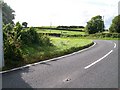
View from the acute bend on the A2 towards the junction with the Crew Road.
Image: © Eric Jones
Taken: 20 Aug 2009
0.21 miles
3
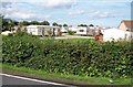
The Coney Island Caravan Park
This occupies the site of the old Killough railway station.
Image: © Eric Jones
Taken: 20 Aug 2009
0.23 miles
4
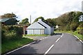
Cottages at the acute bend on the A2 Killough Road
This is a blind bend a little beyond the Killough Bridge.
Image: © Eric Jones
Taken: 20 Aug 2009
0.23 miles
5
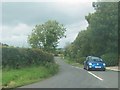
The Crew Road at its junction with the A2
Image: © Eric Jones
Taken: 20 Aug 2009
0.24 miles