IMAGES TAKEN NEAR TO
Downs Road, DOWNPATRICK, BT30 7UB
Introduction
This page details the photographs taken nearby to Downs Road, BT30 7UB by members of the Geograph project.
The Geograph project started in 2005 with the aim of publishing, organising and preserving representative images for every square kilometre of Great Britain, Ireland and the Isle of Man.

There are currently over 7.5m images from over14,400 individuals and you can help contribute to the project by visiting https://www.geograph.org.uk
Image Map
Images are licensed for reuse under creativecommons.org/licenses/by-sa/2.0
Notes
- Clicking on the map will re-center to the selected point.
- The higher the marker number, the further away the image location is from the centre of the postcode.
Image Listing (54 Images Found)
Images are licensed for reuse under creativecommons.org/licenses/by-sa/2.0
Image
Details
Distance
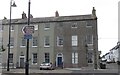
3
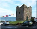
Margaret's Castle at Castle Place
This view is taken from Downs Road. The ruined Margaret's Castle was a late 15th century tower-house.
Image: © Eric Jones
Taken: 20 Aug 2009
0.08 miles
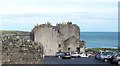
4
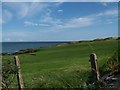
Cowd Castle, Ardglass
This ruined tower-house stands in the grounds of Ardglass Castle. The flags are between the clubhouse and the greens.
Image: © Eric Jones
Taken: 20 Aug 2009
0.09 miles
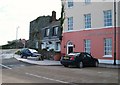
5
Castle Place, Ardglass
These fine Georgian houses in Castle Place were built by William Ogilive who lived in Ardglass Castle (now the Ardglass Golf Clubhouse). He was also responsible for building the harbour at Ardglass.
Image: © Eric Jones
Taken: 22 Jul 2013
0.09 miles
6
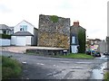
Aldo's Restaurant, Castle Place, Ardglass
http://www.ardglass.net/Aldo's.htm
Image: © Eric Jones
Taken: 20 Aug 2009
0.09 miles
8
Ardglass Castle
Until the late 18thC this was part of a group of medieval fortified warehouses overlooking the harbour entrance and known as the New Works or Newark. In 1790 some of these warehouses were converted by Lord Charles Fitzgerald to form Ardglass Castle. In 1806 it was sold on to William Ogilvie the man who built the fishing harbours at Ardglass. At Ogilvie's death it passed on the Beauclerc family. When Charles Beauclerc, was made bankrupt in 1896, the castle and grounds were purchased by a syndicate of local businessmen who set up a golf course, with the castle serving as the clubhouse. A fortified tower house, known as Horn Castle, was also incorporated into Fitzgerald's castle. This can be seen at the rear of Ardglass Castle and now serves as the club shop.
Image: © Eric Jones
Taken: 20 Aug 2009
0.10 miles
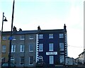
9
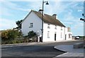
A beautiful white painted house at Castle Place
This stands at the junction with Bri na Ce (Quay Brae), the local name for this part of Kildare Street.
Image: © Eric Jones
Taken: 20 Aug 2009
0.11 miles
10
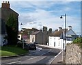
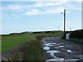
Approaching Castle Place from the South
The ruined Jordan's Castle can be seen beyond the junction.
Image: © Eric Jones
Taken: 20 Aug 2009
0.11 miles